
Triglav topographic map
Interactive map
Click on the map to display elevation.
Triglav
Triglav (pronounced [ˈtɾiːɡlau̯]; German: Terglau; Italian: Tricorno), with an elevation of 2,863.65 metres (9,395.2 ft), is the highest mountain in Slovenia and the highest peak of the Julian Alps. The mountain is the pre-eminent symbol of the Slovene nation, appearing on the coat of arms and flag of Slovenia. It is the centrepiece of Triglav National Park, Slovenia's only national park. Triglav was also the highest peak in Yugoslavia before Slovenia's independence in 1991.
About this map
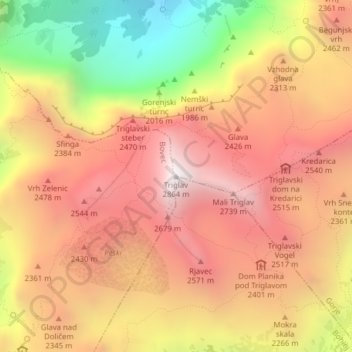
Name: Triglav topographic map, elevation, terrain.
Location: Triglav, Bohinj, Slovenia (46.37825 13.83653 46.37835 13.83663)
Average elevation: 2,161 m
Minimum elevation: 1,169 m
Maximum elevation: 2,835 m
Other topographic maps
Click on a map to view its topography, its elevation and its terrain.
Piran / Pirano
The Municipality of Piran borders Croatia to the south and the municipalities of Izola and Koper to the east, and it faces Italy across the Gulf of Trieste and the Adriatic Sea. The highest point, Baretovec pri Padni, has an elevation of 289 meters (948 ft).
Average elevation: 34 m
Soča
An Alpine river in character, its source lies in the Trenta Valley in the Julian Alps in northwestern Slovenia, at an elevation of 876 metres (2,874 ft). The river runs past the towns of Bovec, Kobarid, Tolmin, Kanal ob Soči, Nova Gorica (where it is crossed by the Solkan Bridge), and Gorizia, entering the…
Average elevation: 562 m
Zreče
The municipality covers an area of 67 square kilometers (26 square miles) at the foothills of the Pohorje range between 360 and 1,517 meters (1,181 and 4,977 ft). The central part of the municipality is highly segmented with much of the northern part with hills with an elevation of over 1,000 meters (3,281…
Average elevation: 794 m