
Soča topographic map
Interactive map
Click on the map to display elevation.
Soča
An Alpine river in character, its source lies in the Trenta Valley in the Julian Alps in northwestern Slovenia, at an elevation of 876 metres (2,874 ft). The river runs past the towns of Bovec, Kobarid, Tolmin, Kanal ob Soči, Nova Gorica (where it is crossed by the Solkan Bridge), and Gorizia, entering the Adriatic Sea close to the town of Monfalcone. It has a nival-pluvial regime in its upper course and pluvial-nival in its lower course.
About this map
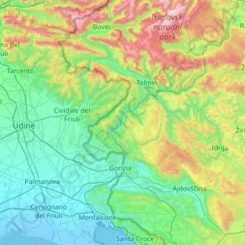
Name: Soča topographic map, elevation, terrain.
Location: Soča, Slovenia (45.72624 13.42757 46.41184 13.75408)
Average elevation: 562 m
Minimum elevation: -6 m
Maximum elevation: 2,722 m
Other topographic maps
Click on a map to view its topography, its elevation and its terrain.
Gornji Slaveči
The name Gornji Slaveči (literally, 'upper Slaveči') contrasts with the name Dolnji Slaveči (literally, 'lower Slaveči'), a village in the neighboring Municipality of Grad. Dolnji Slaveči lies about 20 meters (66 ft) lower in elevation than Gornji Slaveči.
Average elevation: 287 m
Strmec na Predelu
Slovenia > Bovec > Log pod Mangartom
Strmec na Predelu (pronounced [ˈstəɾməts na pɾɛˈdeːlu]; Italian: Bretto di Sopra) is a settlement in the Municipality of Bovec in the Littoral region of Slovenia. It lies on the road to the Predel Pass. Another road, distinguished by being the road built at the highest elevation in Slovenia, splits off…
Average elevation: 1,141 m
Triglav
Triglav (pronounced [ˈtɾiːɡlau̯]; German: Terglau; Italian: Tricorno), with an elevation of 2,863.65 metres (9,395.2 ft), is the highest mountain in Slovenia and the highest peak of the Julian Alps. The mountain is the pre-eminent symbol of the Slovene nation, appearing on the coat of arms and flag of…
Average elevation: 2,161 m
Dolnji Lakoš / Alsólakos
The name Dolnji Lakoš literally means 'lower Lakoš', contrasting with neighboring Gornji Lakoš (literally, 'upper Lakoš'), which is about 1 meter (3 ft 3 in) higher in elevation. The Hungarian name Alsólakos semantically corresponds to the Slovene name and also means 'lower Lakoš'. In the 1380s, the…
Average elevation: 168 m
Golo
Golo is a clustered village with two settlement centers: the hamlets of Gorenje Golo (German: Obergolu) and Dolenje Golo (German: Untergolu). It lies along the road from Ig to Visoko northeast of Mount Mokrec (elevation: 1,059 meters or 3,474 feet). Golec Hill (elevation: 766 meters or 2,513 feet) rises to the…
Average elevation: 579 m