
Rollingergrund topographic map
Interactive map
Click on the map to display elevation.
About this map
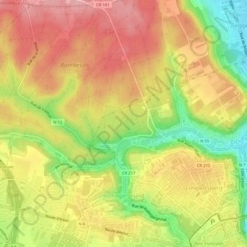
Name: Rollingergrund topographic map, elevation, terrain.
Location: Rollingergrund, Luxembourg, Canton Luxembourg, Luxembourg (49.61356 6.06917 49.64684 6.11929)
Average elevation: 320 m
Minimum elevation: 233 m
Maximum elevation: 385 m
Other topographic maps
Click on a map to view its topography, its elevation and its terrain.