
Jaghori topographic map
Interactive map
Click on the map to display elevation.
About this map
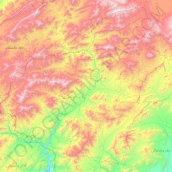
Name: Jaghori topographic map, elevation, terrain.
Location: Jaghori, Ghazni Province, Afghanistan (32.81470 67.08831 33.42971 67.79333)
Average elevation: 2,821 m
Minimum elevation: 1,862 m
Maximum elevation: 4,264 m
Other topographic maps
Click on a map to view its topography, its elevation and its terrain.
Walīdād
Afghanistan > Ghazni Province > Qarabagh > Qarabagh
Walīdād, Qarabagh, Ghazni Province, Afghanistan
Average elevation: 2,097 m
Qarabagh
Qarabagh, Ghazni Province, Afghanistan
Average elevation: 2,525 m