Geolocate

Bethlehem topographic map

Click on the map to display elevation.

About this map

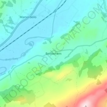
Name: Bethlehem topographic map, elevation, terrain.

Location: Bethlehem, Carmarthenshire, Wales, SA19 6AQ, United Kingdom (51.88950 -3.93095 51.92950 -3.89095)

Average elevation: 115 m

Minimum elevation: 29 m

Maximum elevation: 414 m

Carmarthenshire trails, hiking, mountain biking, running and outdoor activities

Other topographic maps

Click on a map to view its topography, its elevation and its terrain.

River Towy

United Kingdom > Wales > Carmarthenshire

Average elevation: 215 m

Cynwyl Gaeo

United Kingdom > Wales > Carmarthenshire

Average elevation: 254 m

Bryn Iwan

United Kingdom > Wales > Carmarthenshire

Average elevation: 252 m

Whitland

United Kingdom > Wales > Carmarthenshire

Average elevation: 52 m

Llanedi

United Kingdom > Wales > Carmarthenshire > Llanedi

Average elevation: 104 m

Cilycwm

United Kingdom > Wales > Carmarthenshire

Average elevation: 256 m

Coed Tregib

United Kingdom > Wales > Carmarthenshire > Llandeilo

Average elevation: 82 m

Llyn y Fan Fach

United Kingdom > Wales > Carmarthenshire

Llyn y Fan Fach (Welsh meaning "little lake of the peak") is a lake of approximately 10 hectares (25 acres) on the northern margin of the Black Mountain in Carmarthenshire, South Wales and lying within the Brecon Beacons National Park. The lake lies at an altitude of approximately 1,660 feet (510 m),…

Average elevation: 549 m

River Teifi

United Kingdom > Wales > Carmarthenshire

Average elevation: 155 m

Whitland

United Kingdom > Wales > Carmarthenshire > Whitland

Average elevation: 43 m

Llannon

United Kingdom > Wales > Carmarthenshire > Llannon

Average elevation: 144 m

Llanwinio

United Kingdom > Wales > Carmarthenshire

Average elevation: 164 m

Meidrim

United Kingdom > Wales > Carmarthenshire

Average elevation: 91 m

Llanycrwys

United Kingdom > Wales > Carmarthenshire

Average elevation: 248 m

Trelech

United Kingdom > Wales > Carmarthenshire

Average elevation: 182 m

Rhos

United Kingdom > Wales > Carmarthenshire > Rhos

Average elevation: 206 m

Llyn Taliaris

United Kingdom > Wales > Carmarthenshire

Average elevation: 167 m

Whitland

United Kingdom > Wales > Carmarthenshire

Average elevation: 42 m

Llanedi

United Kingdom > Wales > Carmarthenshire > Llanedi

Average elevation: 104 m

Abernant

United Kingdom > Wales > Carmarthenshire

Average elevation: 158 m

Gear up for your next adventure:

🧭Professional Hiking Compasses - High-precision liquid-filled compasses for map reading and orientation
🌂Windproof Trekking Umbrellas - Surprising but effective rain protection on low-wind trails
👟Waterproof Leg Gaiters - Keep mud and water out of your boots in boggy terrain
🔭Compact Hiking Binoculars - Lightweight optics for scouting terrain and spotting wildlife
🥼Base Layers - Thermal base layers for temperature regulation

As an Amazon Associate, this site earns from qualifying purchases at no extra cost to you.