
Akure South topographic map
Interactive map
Click on the map to display elevation.
About this map
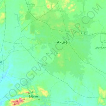
Name: Akure South topographic map, elevation, terrain.
Location: Akure South, Ondo State, Nigeria (7.09251 5.08298 7.35475 5.36516)
Average elevation: 328 m
Minimum elevation: 214 m
Maximum elevation: 947 m
Other topographic maps
Click on a map to view its topography, its elevation and its terrain.
Oluji
Nigeria > Ondo State > Ile Oluji/Okeigbo
Oluji, Ile Oluji/Okeigbo, Ondo State, Nigeria
Average elevation: 261 m