
Zone 3 topographic map
Interactive map
Click on the map to display elevation.
About this map
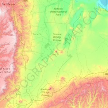
Name: Zone 3 topographic map, elevation, terrain.
Location: Zone 3, Afar, Éthiopie (8.84170 39.75071 11.19894 41.16735)
Average elevation: 1,230 m
Minimum elevation: 240 m
Maximum elevation: 3,797 m
Other topographic maps
Click on a map to view its topography, its elevation and its terrain.
Danakil Depression
Danakil Depression, Zone 2, Afar, Éthiopie
Average elevation: -105 m
Yangudi Rassa National Park
Yangudi Rassa National Park, 18, Zone 3, Afar, Éthiopie
Average elevation: 622 m