
Mille topographic map
Interactive map
Click on the map to display elevation.
About this map
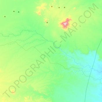
Name: Mille topographic map, elevation, terrain.
Location: Mille, Zone 1, Afar, Éthiopie (11.48310 40.15446 11.64707 40.55735)
Average elevation: 808 m
Minimum elevation: 585 m
Maximum elevation: 1,553 m
Other topographic maps
Click on a map to view its topography, its elevation and its terrain.
Danakil Depression
Danakil Depression, Zone 2, Afar, Éthiopie
Average elevation: -105 m
Yangudi Rassa National Park
Yangudi Rassa National Park, 18, Zone 3, Afar, Éthiopie
Average elevation: 622 m