
Dhaka District topographic map
Interactive map
Click on the map to display elevation.
About this map
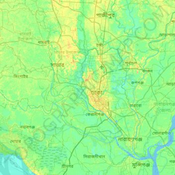
Name: Dhaka District topographic map, elevation, terrain.
Location: Dhaka District, Dhaka Division, Bangladesh (23.51656 90.00993 24.04366 90.51293)
Average elevation: 7 m
Minimum elevation: -2 m
Maximum elevation: 23 m
Other topographic maps
Click on a map to view its topography, its elevation and its terrain.
Dhaka
In 2013, suburban services to Narayanganj and Gazipur cities were upgraded using diesel electric multiple unit trains. The Dhaka Metro Rail feasibility study has been completed. A 20.1-kilometre (12.5 mi), $2.8-billion Phase 1 metro route is being negotiated by the Government with Japan International…
Average elevation: 7 m
Tangail
Bangladesh > Dhaka Division > Tangail Sadar Upazila
The city of Tangail is in Dhaka Division, Central Bangladesh. The town lies in a low-lying floodplain near the Jamuna River, south of the high plateau of the Madhupur tract. The average elevation of Tangail is 14 meters (49 feet). Tangail experiences a Tropical savanna climate(Köppen: Aw ) with a hot, humid…
Average elevation: 11 m
Dhaka
In 2013, suburban services to Narayanganj and Gazipur cities were upgraded using diesel electric multiple unit trains. The Dhaka Metro Rail feasibility study has been completed. A 20.1-kilometre (12.5 mi), $2.8-billion Phase 1 metro route is being negotiated by the Government with Japan International…
Average elevation: 7 m
Tangail
Bangladesh > Dhaka Division > Tangail Sadar Upazila
Tangail was a popular local business centre since the early 19th century. But the name came on focus when the headquarter of a subdivision of the Greater Mymensingh District was shifted in 1860 from Atia to there due to its fertility and high elevation near Louhajong River. At the same time, The subdivision…
Average elevation: 11 m
Buriganga River
Bangladesh > Dhaka Division > Keraniganj Subdistrict > Keraniganj
Average elevation: 8 m