Geolocate

Bedford County topographic map

Interactive map

Click on the map to display elevation.

About this map

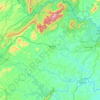
Name: Bedford County topographic map, elevation, terrain.

Location: Bedford County, Virginia, United States (37.00584 -79.85840 37.61825 -79.18543)

Average elevation: 322 m

Minimum elevation: 148 m

Maximum elevation: 1,278 m

Other topographic maps

Click on a map to view its topography, its elevation and its terrain.

Fairfax County

United States > Virginia

Most of the county lies in the Piedmont region, with rolling hills and deep stream valleys such as Difficult Run and its tributaries. West of Route 28, the hills give way to a flat, gentle valley that stretches west to the Bull Run Mountains in Loudoun County. Elevations in the county range from near sea level…

Average elevation: 75 m

Leesburg

United States > Virginia > Loudoun County

Leesburg is located northeast of the center of Loudoun County at 39°7′N 77°33′W / 39.117°N 77.550°W / 39.117; -77.550 (39.109, −77.558), It is part of the northern Virginia Piedmont and sits at the base of the easternmost chain of the Blue Ridge Mountains, Catoctin Mountain. The town lies in…

Average elevation: 113 m

Norfolk

United States > Virginia > Norfolk

Average elevation: 4 m

Henrico County

United States > Virginia

Average elevation: 43 m

Charlottesville

United States > Virginia

Average elevation: 138 m

Virginia Beach

United States > Virginia > Virginia Beach

According to the United States Census Bureau, the city has a total area of 497 square miles (1,290 km2), of which 249 square miles (640 km2) is land and 248 square miles (640 km2) (49.9%) is water. It is the largest city in Virginia by total area and third-largest city land area. The average elevation is 12…

Average elevation: 2 m

Orange County

United States > Virginia

According to the U.S. Census Bureau, the county has a total area of 343 square miles (890 km2), of which 341 square miles (880 km2) is land and 2.5 square miles (6.5 km2) (0.7%) is water. The terrain is characterized by rolling hills, generally increasing in altitude and slope as they continue westward toward…

Average elevation: 133 m

Sterling

United States > Virginia > Loudoun County

According to the USGS, Sterling has an average elevation of 289 feet (88 m) above sea level. The original center of Sterling is located at 39°00'22.4"N 77°25'43.0"W. Sterling is part of the Chesapeake Bay watershed, and Greater Sterling borders the Potomac River.

Average elevation: 97 m

Prince William County

United States > Virginia

Average elevation: 107 m

Hopewell

United States > Virginia

Average elevation: 16 m

Blacksburg

United States > Virginia > Montgomery County

In the mid-1600s, English colonists were still uncertain of what lay beyond the Allegheny Mountains, whose topography and possession by native inhabitants, Tutelo-speaking tribes, were a barrier to expanded settlement by the Colony of Virginia. Abraham Wood, who commanded Fort Henry on the frontier (now the…

Average elevation: 621 m

Oak Hall

United States > Virginia > Accomack County

It lies at an elevation of 26 feet.

Average elevation: 10 m

Southampton County

United States > Virginia

Average elevation: 24 m

Pinewell

United States > Virginia > Norfolk

Average elevation: 3 m

Bassett

United States > Virginia > Henry County

Average elevation: 271 m

Mantua

United States > Virginia > Fairfax County

Average elevation: 104 m

Ivy

United States > Virginia > Albemarle County

Average elevation: 187 m

Simeon

United States > Virginia > Albemarle County

Average elevation: 161 m

Lithia

United States > Virginia > Botetourt County

Average elevation: 342 m

Ballentine Place

United States > Virginia > Norfolk

Average elevation: 6 m

Saint George

United States > Virginia > Greene County

Average elevation: 294 m

Doe Mountain

United States > Virginia > Giles County

Average elevation: 1,003 m

Augusta County

United States > Virginia

Average elevation: 569 m

Appomattox

United States > Virginia > Appomattox County

Average elevation: 250 m

Amelia

United States > Virginia > Amelia County

Average elevation: 107 m

North Garden

United States > Virginia > Albemarle County

Average elevation: 217 m

Lindsay

United States > Virginia > Albemarle County

Average elevation: 154 m

Kilmarnock

United States > Virginia > Lancaster County

Average elevation: 16 m

Castle Craig

United States > Virginia > Campbell County

Average elevation: 237 m

Altavista

United States > Virginia > Campbell County

Average elevation: 200 m

Duffield

United States > Virginia > Scott County

Average elevation: 457 m

Roseland

United States > Virginia > Nelson County

Average elevation: 225 m

Montpelier

United States > Virginia > Hanover County

Average elevation: 90 m

Blue Ridge Mountains

United States > Virginia > Bedford County

Although the term "Blue Ridge" is sometimes applied exclusively to the eastern edge or front range of the Appalachian Mountains, the geological definition of the Blue Ridge province extends westward to the Ridge and Valley area, encompassing the Great Smoky Mountains, the Great Balsams, the Roans, the Blacks,…

Average elevation: 548 m

Brumley Gap

United States > Virginia > Washington County

Average elevation: 602 m

Blue Ridge Mountains

United States > Virginia > Botetourt County

Although the term "Blue Ridge" is sometimes applied exclusively to the eastern edge or front range of the Appalachian Mountains, the geological definition of the Blue Ridge province extends westward to the Ridge and Valley area, encompassing the Great Smoky Mountains, the Great Balsams, the Roans, the Blacks,…

Average elevation: 460 m

Norton

United States > Virginia

Average elevation: 795 m

Greenlee

United States > Virginia > Rockbridge County

Average elevation: 285 m

Monterey

United States > Virginia > Highland County

Average elevation: 921 m

Caroline County

United States > Virginia

Average elevation: 53 m

Abilene

United States > Virginia > Charlotte County

Average elevation: 167 m

Barhamsville

United States > Virginia > New Kent County

Average elevation: 26 m

Rochelle

United States > Virginia > Madison County

Average elevation: 157 m

Oak Hill

United States > Virginia > Pittsylvania County

Average elevation: 165 m

Short Mtn

United States > Virginia > Frederick County

Average elevation: 561 m