
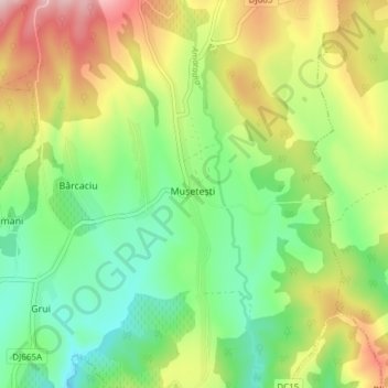
Gorj topographic map
Interactive map
Click on the map to display elevation.
About this map
Name: Gorj topographic map, elevation, terrain.
Location: Mușetești, Gorj, Romania (45.11335 23.45259 45.16654 23.46841)
Average elevation: 387 m
Minimum elevation: 279 m
Maximum elevation: 556 m
Other topographic maps
Click on a map to view its topography, its elevation and its terrain.
Bucharest
The city has an area of 226 km2 (87 sq mi). The altitude varies from 55.8 m (183.1 ft) at the Dâmbovița bridge in Cățelu, southeastern Bucharest and 91.5 m (300.2 ft) at the Militari church. The city has a roughly round shape, with the centre situated in the cross-way of the main north–south/east-west…
Average elevation: 82 m
Cluj-Napoca
A wide variety of flora grow in the Cluj-Napoca Botanical Garden; some animals have also found refuge there. The city has a number of other parks, of which the largest is the Central Park. This park was founded during the 19th century and includes an artificial lake with an island, as well as the largest…
Average elevation: 490 m
Carpathian Mountains
The northwestern Carpathians begin in Slovakia and southern Poland. They surround Transcarpathia and Transylvania in a large semicircle, sweeping towards the southeast, and end on the Danube near Orșova in Romania. The total length of the Carpathians is over 1,500 km (930 mi). The mountain chain's width…
Average elevation: 980 m
Bucura Lake
Romania > Hunedoara > Râu de Mori
Lake Bucura is a glacier cirque lake, situated in the Retezat Mountains, in Romania. It is located south of the main ridge, at the base of Peleaga Peak, and at an altitude of about 2,040 m.
Average elevation: 2,137 m
Timis
In the spring of 2007 works on the elevation of the embankments on both banks of the river began, 11.5 kilometers (7.1 mi) on the right bank and 13.2 kilometers (8.2 mi) on the left. The embankments will be 30–70 cm (12–28 in) higher than they are now and being higher than 8.5 m (28 ft) should prevent any…
Average elevation: 188 m
Teregova
The commune is located in the east-central part of county, stretching eastwards to the border with Hunedoara County. It is situated at an altitude of 424 m (1,391 ft), at the foot of the Țarcu Mountains. The river Timiș flows through Rusca village; its right tributary, the river Teregova, joins the Timiș in…
Average elevation: 803 m