
Heath and Reach topographic map
Interactive map
Click on the map to display elevation.
About this map
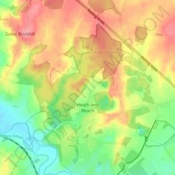
Name: Heath and Reach topographic map, elevation, terrain.
Location: Heath and Reach, Central Bedfordshire, England, United Kingdom (51.93401 -0.68300 51.96828 -0.60979)
Average elevation: 120 m
Minimum elevation: 75 m
Maximum elevation: 165 m
Central Bedfordshire trails, hiking, mountain biking, running and outdoor activities
Other topographic maps
Click on a map to view its topography, its elevation and its terrain.
Lower Caldecote
United Kingdom > England > Central Bedfordshire > Upper Caldecote
Average elevation: 32 m
Houghton Hall Park
United Kingdom > England > Central Bedfordshire > Houghton Regis
Average elevation: 134 m
Edgecote
United Kingdom > England > Central Bedfordshire > Caddington > Aley Green
Average elevation: 168 m
Dunstable Downs
United Kingdom > England > Central Bedfordshire > Church End
Because of its elevation, Dunstable Downs hosted a station in the shutter telegraph chain which connected the Admiralty in London to its naval ships in the port of Great Yarmouth during the years 1808 to 1814.
Average elevation: 178 m
Wrestlingworth
United Kingdom > England > Central Bedfordshire > Wrestlingworth
Average elevation: 47 m