
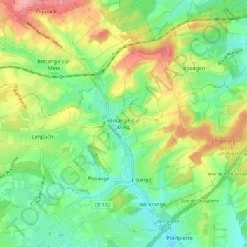
Reckange-sur-Mess topographic map
Interactive map
Click on the map to display elevation.
About this map
Name: Reckange-sur-Mess topographic map, elevation, terrain.
Location: Reckange-sur-Mess, Canton Esch-sur-Alzette, Luxembourg (49.53575 5.96074 49.58670 6.04980)
Average elevation: 320 m
Minimum elevation: 280 m
Maximum elevation: 384 m
Other topographic maps
Click on a map to view its topography, its elevation and its terrain.
Rattem
Luxembourg > Canton Esch-sur-Alzette > Differdange
Rattem, Differdange, Canton Esch-sur-Alzette, 4658, Luxembourg
Average elevation: 345 m
Schifflange
Luxembourg > Canton Esch-sur-Alzette
Schifflange, Canton Esch-sur-Alzette, Luxembourg
Average elevation: 309 m
Niederkorn
Luxembourg > Canton Esch-sur-Alzette > Differdange
Niederkorn, Differdange, Canton Esch-sur-Alzette, 4555, Luxembourg
Average elevation: 329 m
Peppange
Luxembourg > Canton Esch-sur-Alzette
Peppange, Roeser, Canton Esch-sur-Alzette, 3391, Luxembourg
Average elevation: 278 m
Esch-sur-Alzette
Luxembourg > Canton Esch-sur-Alzette
Esch-sur-Alzette, Canton Esch-sur-Alzette, Luxembourg
Average elevation: 332 m
Soleuvre
Luxembourg > Canton Esch-sur-Alzette
Soleuvre, Sanem, Canton Esch-sur-Alzette, 4440, Luxembourg
Average elevation: 322 m
Abweiler
Luxembourg > Canton Esch-sur-Alzette > Bettembourg
Abweiler, Bettembourg, Canton Esch-sur-Alzette, 3311, Luxembourg
Average elevation: 296 m
Kockelscheuer
Luxembourg > Canton Esch-sur-Alzette > Roeser
Kockelscheuer, Roeser, Canton Esch-sur-Alzette, 1899, Luxembourg
Average elevation: 299 m
Dudelange
Luxembourg > Canton Esch-sur-Alzette
Dudelange, Canton Esch-sur-Alzette, Luxembourg
Average elevation: 317 m
Belvaux
Luxembourg > Canton Esch-sur-Alzette
Belvaux, Sanem, Canton Esch-sur-Alzette, 4450, Luxembourg
Average elevation: 327 m
Pétange
Luxembourg > Canton Esch-sur-Alzette
Pétange, Canton Esch-sur-Alzette, Luxembourg
Average elevation: 317 m
Belval
Luxembourg > Canton Esch-sur-Alzette > Esch-sur-Alzette
Belval, Esch-sur-Alzette, Canton Esch-sur-Alzette, 4024, Luxembourg
Average elevation: 307 m
Huncherange
Luxembourg > Canton Esch-sur-Alzette > Bettembourg
Huncherange, Bettembourg, Canton Esch-sur-Alzette, 3341, Luxembourg
Average elevation: 288 m
Ehlerange
Luxembourg > Canton Esch-sur-Alzette
Ehlerange, Sanem, Canton Esch-sur-Alzette, 4384, Luxembourg
Average elevation: 309 m
Mondercange
Luxembourg > Canton Esch-sur-Alzette > Mondercange
Mondercange, Canton Esch-sur-Alzette, Luxembourg
Average elevation: 310 m
Oberkorn
Luxembourg > Canton Esch-sur-Alzette > Differdange > Oberkorn
Oberkorn, Differdange, Canton Esch-sur-Alzette, 4649, Luxembourg
Average elevation: 358 m
Tétange
Luxembourg > Canton Esch-sur-Alzette
Tétange, Kayl, Canton Esch-sur-Alzette, 3776, Luxembourg
Average elevation: 347 m
Bettembourg
Luxembourg > Canton Esch-sur-Alzette
Bettembourg, Canton Esch-sur-Alzette, Luxembourg
Average elevation: 289 m
Differdange
Luxembourg > Canton Esch-sur-Alzette
Differdange, Canton Esch-sur-Alzette, Luxembourg
Average elevation: 352 m
Sanem
Luxembourg > Canton Esch-sur-Alzette
Sanem, Canton Esch-sur-Alzette, Luxembourg
Average elevation: 322 m
Kayl
Luxembourg > Canton Esch-sur-Alzette
Kayl, Canton Esch-sur-Alzette, Luxembourg
Average elevation: 341 m
Rumelange
Luxembourg > Canton Esch-sur-Alzette
Rumelange, Canton Esch-sur-Alzette, Luxembourg
Average elevation: 367 m
Foetz
Luxembourg > Canton Esch-sur-Alzette
Foetz, Mondercange, Canton Esch-sur-Alzette, 3895, Luxembourg
Average elevation: 294 m