
Finland topographic map
Click on the map to display elevation.
About this map
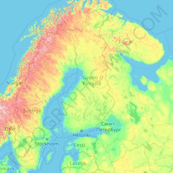
Name: Finland topographic map, elevation, terrain.
Location: Finland (55.74678 18.42092 70.74678 33.42092)
Average elevation: 163 m
Minimum elevation: -3 m
Maximum elevation: 1,816 m
Other topographic maps
Click on a map to view its topography, its elevation and its terrain.
Espoo
The minerals and structures of the rocky and hilly topography of Espoo were formed about 1880 to 1650 million years ago. Particularly the Weichselian glaciation has had an effect on the current environment - the continental ice sheet withdrew from what is now Espoo about 13 thousand years ago. The first areas…
Average elevation: 22 m
Turku
Operational since 1955, the city's weather station is located at an altitude of 47 metres (154 feet) at Turku Airport. The weather in the city itself is affected by the proximity of the sea, so the wintertime temperatures are often milder than those measured at the airport. The moderating impact of the sea…
Average elevation: 32 m
Orivesi
Orivesi has more than 350 lakes. The landscape of Orivesi is mostly dominated by Lake Längelmävesi, into which most of the area's water basis fall. The northeastern end of Kangasala's Lake Vesijärvi also extends to the Orivesi area. Some of the lakes in the western part of Orivesi flow into Lake…
Average elevation: 127 m
Turku
Operational since 1955, the city's weather station is located at an altitude of 47 metres (154 feet) at Turku Airport. The weather in the city itself is affected by the proximity of the sea, so the wintertime temperatures are often milder than those measured at the airport. The moderating impact of the sea…
Average elevation: 32 m
Märket
Finland > Åland Islands > Åland Islands > Hammarland
The island consists of mostly smooth diabase rock, with a maximum natural elevation of 2 m (6.6 ft). Most of the area is regularly washed over with seawater in storms, and scoured by drift ice in winter. Plant life, which is limited to low-growing grasses and herbs, persists only in some protected spots.…
Average elevation: 0 m
Enontekiö
The lower heathlands are dominated by shrubs such as Betula nana, Vaccinium myrtillus and Empetrum hermaphroditum, whereas in the fjell heaths at higher elevations Salix herbacea, Empetrum and alpine grasses with lichens and mosses occur. In the mountains of the north-west Cassiope tetragona is abundant. The…
Average elevation: 405 m
Pielinen
The lake is located at an elevation of 93.7 m (307 ft) in the North Karelia region in eastern Finland. It has a water spread area of 894.21 km2 (345.26 sq mi) and a shore length of 1,700 km (1,100 mi), and is bound within geographical coordinates of 62°54–63°33N and 29°07–30°14E. The maximum length is…
Average elevation: 134 m
Turku
Operational since 1955, the city's weather station is located at an altitude of 47 metres (154 feet) at Turku Airport. The weather in the city itself is affected by the proximity of the sea, so the wintertime temperatures are often milder than those measured at the airport. The moderating impact of the sea…
Average elevation: 32 m
Märket
Finland > Åland Islands > Åland Islands > Hammarland
The island consists of mostly smooth diabase rock, with a maximum natural elevation of 2 m (6.6 ft). Most of the area is regularly washed over with seawater in storms, and scoured by drift ice in winter. Plant life, which is limited to low-growing grasses and herbs, persists only in some protected spots.…
Average elevation: 0 m
Lapland
Lapland is the largest and northernmost region of Finland. The 21 municipalities in the region cooperate in a Regional Council. Lapland borders the Finnish region of North Ostrobothnia in the south. It also borders the Gulf of Bothnia and the Norrbotten County in Sweden, Finnmark County and the Troms County in…
Average elevation: 249 m
Orivesi
Orivesi has more than 350 lakes. The landscape of Orivesi is mostly dominated by Lake Längelmävesi, into which most of the area's water basis fall. The northeastern end of Kangasala's Lake Vesijärvi also extends to the Orivesi area. Some of the lakes in the western part of Orivesi flow into Lake…
Average elevation: 127 m
Kuusamo
The city lies on a roughly 250-meter-high plateau, from which the waters flow in five directions. In the area of Kuusamo there are many hills (Finn. vaara) and fells (Finn. tunturi). The highest elevations are Valtavaara (492 m), Kuntivaara (481 m), Iivaara (469 m) and Rukatunturi (492 m), the site of the Ruka…
Average elevation: 266 m