
Tujereng topographic map
Interactive map
Click on the map to display elevation.
About this map
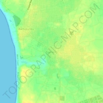
Name: Tujereng topographic map, elevation, terrain.
Location: Tujereng, Brikama, West Coast Division, The Gambia (13.29793 -16.80892 13.33793 -16.76892)
Average elevation: 12 m
Minimum elevation: 0 m
Maximum elevation: 22 m
Other topographic maps
Click on a map to view its topography, its elevation and its terrain.
Salagi Forest Park
The Gambia > West Coast Division > Kombo North/Saint Mary > Labakoreh
Average elevation: 23 m
Bijilo Forest Park
The Gambia > West Coast Division > Kombo North/Saint Mary > Sukuta
Average elevation: 13 m
Abuko
The Gambia > West Coast Division > Kombo North/Saint Mary
Abuko is 15 metres (49 ft) above sea level. The surrounding land is mainly flat. The highest point nearby has an elevation of 26 metres (85 ft), 1 kilometre (0.62 mi) south of Abuko. The vegetation around Abuko is almost all fields. Peninsulas and islands are common in the region.
Average elevation: 15 m