
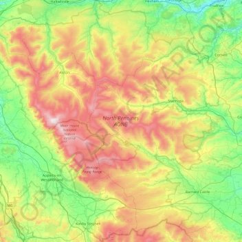
North Pennines National Landscape topographic map
Interactive map
Click on the map to display elevation.
About this map
Name: North Pennines National Landscape topographic map, elevation, terrain.
Average elevation: 325 m
Minimum elevation: 12 m
Maximum elevation: 892 m
County Durham trails, hiking, mountain biking, running and outdoor activities
Other topographic maps
Click on a map to view its topography, its elevation and its terrain.
Mickle Fell
United Kingdom > England > County Durham
Mickle Fell is a mountain in the Pennines, the range of hills and moors running down the middle of Northern England. It has a maximum elevation of 788 m (2,585 ft). It lies slightly off the main watershed of the Pennines, about 10 miles (16 kilometres) south of Cross Fell. After Cross Fell, Mickle Fell is the…
Average elevation: 658 m
West Shield Row Villas
United Kingdom > England > County Durham > Stanley > Tanfield Lea
Average elevation: 180 m
High Shincliffe
United Kingdom > England > County Durham
High Shincliffe is a village in County Durham, England. It is situated about two miles south-east of Durham City, on the A177 road to Stockton-on-Tees. The altitude of High Shincliffe is approximately 90 metres (300 ft), and it lies 55 metres (180 ft) above the River Wear at Shincliffe bridge. Latest…
Average elevation: 77 m
Bishop Middleham Quarry Nature Reserve
United Kingdom > England > County Durham > Bishop Middleham
Average elevation: 115 m
West Butsfield
United Kingdom > England > County Durham > Satley > West Butsfield
Average elevation: 259 m
Copley
United Kingdom > England > County Durham
Copley has its own weather station run by the Met Office and Environment Agency. Because of its elevation above sea-level, around the 1,000 ft contour, and position in the north-east, this station is often one of the coldest in England with high incidences of ground frosts and snowfalls. Copley is in a…
Average elevation: 261 m