
Moravia-Silesia topographic map
Interactive map
Click on the map to display elevation.
About this map
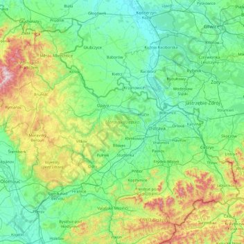
Name: Moravia-Silesia topographic map, elevation, terrain.
Location: Moravia-Silesia, Czechia (49.39259 17.14653 50.32798 18.85925)
Average elevation: 386 m
Minimum elevation: 164 m
Maximum elevation: 1,475 m
Other topographic maps
Click on a map to view its topography, its elevation and its terrain.
Rychtářov
Czechia > South Moravian Region > Vyškov
Rychtářov (German: Richtersdorf) is a former village, today a part of the town of Vyškov in the South Moravian Region of the Czech Republic. Located approximately 10 kilometres (6 mi) north of Vyškov and 27 kilometres (17 mi) north-east of Brno, it lies at an altitude of 401 m above sea level. Rychtářov…
Average elevation: 402 m
Říp
Czechia > Northwest > Ústí nad Labem Region > Mnetěš
The name of the mountain is of pre-Slavic origin and probably comes from the Old-Germanic stem ríp- (elevation, hill), which has the Latin parallel in the word rípa (shore, slope, hillside). Some linguists also derive the origin of the name from the Illyrian-Thracian base.
Average elevation: 264 m
Klínovec
Czechia > Northwest > Karlovy Vary Region > Jáchymov
Klínovec (German: Keilberg) is the highest peak of the Ore Mountains, located in the Czech Republic's part of the mountains at 1,244 metres (4,081 ft). There is an 80 m TV broadcasting tower on the top of the mountain and a 24 meter high lookout tower. From the south side, the Jáchymov - Klínovec chairlift…
Average elevation: 1,082 m
Brná
Czechia > Northwest > Ústí nad Labem Region > Ústí nad Labem
Among border points there are hills Kamenný vrch, Skřivánčí vrch and Modřín. There is Průčelský stream in Brná nad Labem and elevation is between 170 and 700 meters above sea level.
Average elevation: 366 m
Historic Centre of Český Krumlov
Czechia > Southwest > South Bohemian Region > Český Krumlov
Average elevation: 542 m
Letná Park
Letná Park (Czech: Letenské sady) is a large park on Letná hill, built on a plateau above steep embankments along the Vltava River in Prague, Czech Republic. Letná's elevation and location afford commanding views of the Prague Old Town (Staré Město).
Average elevation: 214 m
Velká Deštná
Czechia > Northeast > Královéhradecký kraj > Deštné v Orlických horách
Velká Deštná (German: Deschneyer Großkoppe) is a mountain in the Hradec Králové Region of the Czech Republic. With an elevation of 1,116 m (3,661 ft), it is the highest mountain of the Orlické Mountains and of the whole Central Sudetes range. There is an observation tower on top of the mountain, which…
Average elevation: 962 m
Ore Mountains
Czechia > Northwest > Ústecký kraj > Loučná pod Klínovcem
The topographical transition from the Western and Central Ore Mountains to the loess hill country to the north between Zwickau and Chemnitz is referred to as the Ore Mountain Basin; that from the Eastern Ore Mountains as the Ore Mountain Foreland. Between Freital and Pirna, the area is called the Dresden Ore…
Average elevation: 1,020 m