
Ozark County topographic map
Interactive map
Click on the map to display elevation.
About this map
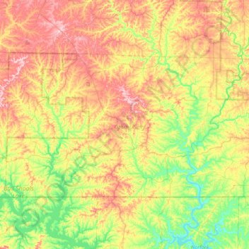
Name: Ozark County topographic map, elevation, terrain.
Location: Ozark County, Missouri, United States (36.49720 -92.77433 36.80602 -92.11402)
Average elevation: 279 m
Minimum elevation: 163 m
Maximum elevation: 452 m
Other topographic maps
Click on a map to view its topography, its elevation and its terrain.
Richard L. Berkley Riverfront Park
United States > Missouri > Jackson County > Kansas City
Average elevation: 242 m
Mississippi & Missouri River Confluence Point
United States > Missouri > Saint Charles County > West Alton
Average elevation: 126 m
Iron County
Taum Sauk Mountain /ˈtɔːm ˈsɔːk/ in the Saint Francois Mountains is the highest natural point in the U.S. state of Missouri at 1,772 feet (540 m). The topography of Taum Sauk is that of an elongated ridge with a NNW-SSE orientation rather than a peak.
Average elevation: 466 m
University City
United States > Missouri > Saint Louis County > University City > University City
Average elevation: 170 m
Downtown Kansas City
United States > Missouri > Jackson County > Downtown Kansas City
Average elevation: 271 m
Town and Country
United States > Missouri > Saint Louis County > Town and Country > Town and Country
Average elevation: 178 m