
Americas topographic map
Interactive map
Click on the map to display elevation.
About this map
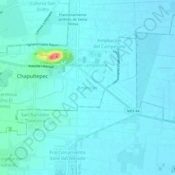
Name: Americas topographic map, elevation, terrain.
Location: Americas, State of Mexico, 52145, Mexico (19.17829 -99.56868 19.21829 -99.52868)
Average elevation: 2,579 m
Minimum elevation: 2,570 m
Maximum elevation: 2,659 m
Other topographic maps
Click on a map to view its topography, its elevation and its terrain.
Tenancingo
The seat of the municipality is the town of Tenancingo, surrounded by mountains and forest. The main elevation overlooking the town is the Cerro de las Tres Marías, topped by a giant white statue of Christ the King (Cristo Rey), built in 1985, designed by Hector Morret and visible from just about anywhere in…
Average elevation: 2,053 m
Malinalco
As municipal seat, the town of Malinalco is the governing authority over 54 other named communities, which covers an area of 186.28km2. The municipality, which shares its name with the seat, has a population of 22,970 of which only 6,523 live in the town of Malinalco. It has an average elevation of 1750 meters…
Average elevation: 1,871 m
Metepec
Metepec (Spanish: [meteˈpek] ) is a municipality in the State of Mexico in Mexico and is located directly to the east of the state capital, Toluca, at an altitude of 2,635 metres (8,645 ft) above sea level. The center of Mexico City lies some 50 km further to the east. The city of Metepec also form part of…
Average elevation: 2,625 m
Atlacomulco
The municipality has rugged terrain, filled with mountains and hills. It is located on the Trans-Mexican Volcanic Belt, in the Lakes and Volcanos of Anáhuac region. Principle elevations include Cerro Xitije, Cerro Atlacomulco, Cerro La Cruz and Cerro El Cielito. Its altitude varies from 2720 to 3030 meters…
Average elevation: 2,665 m
Acolman
The municipality is located on a plain in the northern portion of the Valley of Mexico called the Valley of Teotihuacan. It has only three significant elevations. The eastern border is marked by the Sierra de Patlachique and the west is marked by a mountain called Chiconautla. Chiconautla and Tlahuilco are…
Average elevation: 2,298 m
Temascalcingo
The town today has an altitude of 2,380 meters and in 2005 had a population of 11,454 people. The town is centered on a square called the Plaza Centenario, with its Municipal Palace to the south of the square. To the north is another, smaller square dedicated to painter José María Velasco.
Average elevation: 2,603 m
Nezahualcóyotl
The municipality has a territory of 63.44 km2, 81% of which is occupied by the city, which consists of 86 neighborhoods called colonias. The rest is part of the Federal Zone of the Ex-Basin of Texcoco. The municipality is flat with only one elevation reading 1,220 meters above sea level. The Los Remedios and a…
Average elevation: 2,235 m
La Paz
Mexico > State of Mexico > La Paz
The city, in west-central Bolivia 68 km (42 mi) southeast of Lake Titicaca, is set in a canyon created by the Choqueyapu River. It is in a bowl-like depression, part of the Amazon basin, surrounded by the high mountains of the Altiplano. Overlooking the city is the towering, triple-peaked Illimani. Its peaks…
Average elevation: 2,324 m
Calimaya
The land in the municipality is mostly flat, with the west side. The highest elevation is 4,578 meters above sea level, which is located on the slopes of the Nevada de Toluca. The lowest elevation is 2,600. In addition to the Nevado, another elevation is the Tepemaxalco Mountain, popularly known as the Cerro…
Average elevation: 2,882 m
Tonatico
Mexico > State of Mexico > Tonatico
Tonatico has several nearby mountains, including La Cruz and Tapachichi. The largest is La Puerta at 1,685 meters of elevation. The Salto de Zumpantitlán waterfall is nearby, along with the Tenancingo, San Geronimo and Taplalla rivers.
Average elevation: 1,617 m