
Central Coast topographic map
Interactive map
Click on the map to display elevation.
About this map
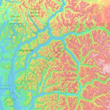
Name: Central Coast topographic map, elevation, terrain.
Location: Central Coast, British Columbia, Canada (51.48296 -127.76188 52.76296 -126.48188)
Average elevation: 789 m
Minimum elevation: -1 m
Maximum elevation: 2,967 m
Other topographic maps
Click on a map to view its topography, its elevation and its terrain.
Grave Island
Canada > British Columbia > Regional District of Mount Waddington > Area A (Seymour Inlet/Knight Inlet)
Average elevation: 9 m
Howe Sound
Canada > British Columbia > Sunshine Coast Regional District > Area F (West Howe Sound)
Average elevation: 529 m
Harrison Hot Springs
Canada > British Columbia > Fraser Valley Regional District
Average elevation: 203 m
Hatzic Lake
Canada > British Columbia > Fraser Valley Regional District > Area G (Deroche/Dewdney/Sumas Mountain)
Average elevation: 43 m
Harrison Lake
Canada > British Columbia > Fraser Valley Regional District > Area C (Sasquatch Country)
Average elevation: 815 m
Copeland Creek
Canada > British Columbia > Columbia-Shuswap Regional District > Area B (Shelter Bay/Mica Creek)
Average elevation: 1,588 m
Dunbar-Southlands
Canada > British Columbia > Metro Vancouver Regional District > Vancouver
Average elevation: 43 m
Area A (Wynndel/Crawford Bay/Riondel)
Canada > British Columbia > Regional District of Central Kootenay
Average elevation: 1,574 m
Kootenay National Park
Canada > British Columbia > Regional District of East Kootenay
Kootenay National Park is a national park of Canada in southeastern British Columbia. The park consists of 1,406 km2 (543 sq mi) of the Canadian Rockies, including parts of the Kootenay and Park mountain ranges, the Kootenay River and the entirety of the Vermilion River. While the Vermilion River is completely…
Average elevation: 1,832 m
Baron Lake
Canada > British Columbia > Regional District of Kitimat-Stikine > Area C (Butedale/Kitlope/Kitsumkalum)
Average elevation: 331 m
Boyle Rocks
Canada > British Columbia > Central Coast Regional District > Area A (Ocean Falls/Outer Coast)
Average elevation: 5 m
Area J (Copper Desert Country)
Canada > British Columbia > Thompson-Nicola Regional District
Average elevation: 1,128 m
Harry Wipper Park
Canada > British Columbia > Regional District of Nanaimo > Nanaimo
Average elevation: 77 m
Ducie Island
Canada > British Columbia > North Coast Regional District > Area A (North Skeena)
Average elevation: 1 m
Lelu Island
Canada > British Columbia > North Coast Regional District > Port Edward
Average elevation: 23 m
Spruce Lake
Canada > British Columbia > Squamish-Lillooet Regional District > Area A (Upper Bridge River Valley)
Average elevation: 1,688 m
Crooked River Provincial Park
Canada > British Columbia > Regional District of Fraser-Fort George > Area G (Crooked River/Parsnip) > Bear Lake
Average elevation: 716 m
Moose Lake
Canada > British Columbia > Cariboo Regional District > Area G (Lac La Hache/108 Mile Ranch)
Average elevation: 1,176 m
Serpentine Lake
Canada > British Columbia > Squamish-Lillooet Regional District > Area B (Cayoosh/Pavilion)
Average elevation: 1,923 m
Area B (Halfmoon Bay)
Canada > British Columbia > Sunshine Coast Regional District
Average elevation: 464 m
Area B (Finlay Valley/Beatton Valley)
Canada > British Columbia > Peace River Regional District
Average elevation: 1,098 m
Moberly Lake
Canada > British Columbia > Peace River Regional District > Area E (Moberly Lake/Sukunka Valley)
Average elevation: 886 m
Area A (Osoyoos Lake)
Canada > British Columbia > Regional District of Okanagan-Similkameen
Average elevation: 1,012 m
Capilano Lake
Canada > British Columbia > Metro Vancouver Regional District > West Vancouver
Average elevation: 353 m
Wells
Canada > British Columbia > Cariboo Regional District
Wells doesn't have a weather station, but Barkerville does (located 7 km (4.3 mi) away). Wells has a subarctic climate (Köppen climate classification Dfc), resulting in long, cold and snowy winters, accompanied by short and cool summers due to its high altitude and latitude. Its growing season averages only…
Average elevation: 1,439 m
Area C (Bowron Lake/Barlow Creek/Barkerville)
Canada > British Columbia > Cariboo Regional District
Average elevation: 1,399 m
Kettle Lakes
Canada > British Columbia > Regional District of Fraser-Fort George > Area H (Robson Valley/Canoe)
Average elevation: 1,189 m
Pemberton
Canada > British Columbia > Squamish-Lillooet Regional District
The climate of Pemberton is very warm and dry in the summer and mild and wet in the winter. Pemberton is an ecologically complex and diverse zone which is referred to as the Coast-Interior Transition zone. Moving from west to east in the direction of the prevailing winds and taking into consideration the…
Average elevation: 1,005 m
Area F (McConnell Creek/Hatzic Prairie)
Canada > British Columbia > Fraser Valley Regional District
Average elevation: 832 m
Seton Lake
Canada > British Columbia > Squamish-Lillooet Regional District > Area B (Cayoosh/Pavilion)
The lake is bounded by snow-capped mountains that descend abruptly to the shores. Environmental conditions largely mirror the Anderson Lake geology, topography, and climate. However, glacial silt from Cayoosh Creek, entering via the power station tunnel, makes the lake water much cloudier than Anderson.
Average elevation: 1,339 m
Area D (Kiskatinaw Valley)
Canada > British Columbia > Peace River Regional District
Average elevation: 1,024 m
Stump Lake
Canada > British Columbia > Regional District of Kootenay Boundary > Area E (Beaverdell/West Boundary)
Average elevation: 1,321 m
Area C (Butedale/Kitlope/Kitsumkalum)
Canada > British Columbia > Regional District of Kitimat-Stikine
Average elevation: 639 m
Kelowna
Canada > British Columbia > Regional District of Central Okanagan
Kelowna is classified as a humid continental climate or an inland oceanic climate per the Köppen climate classification system due to its coldest month having an average temperature slightly above −3.0 °C (26.6 °F) and below 0 °C (32 °F), with dry, hot, sunny summers and cool, cloudy winters, and four…
Average elevation: 704 m
University of British Columbia
Canada > British Columbia > Metro Vancouver Regional District > Electoral Area A
Average elevation: 58 m
Lake O'Hara
Canada > British Columbia > Columbia-Shuswap Regional District > Area A (Kicking Horse/Kinbasket Lake)
Lake O'Hara is a lake at an elevation of 2,020 metres (6,630 ft) in the alpine area of Yoho National Park, in the province of British Columbia, on the western side of the Great Divide with the province of Alberta and Banff National Park to the east. The lake and the valley are accessible through a bus service…
Average elevation: 2,276 m
Findlay Creek
Canada > British Columbia > Regional District of East Kootenay > Area F (Columbia Lake/Windermere Lake)
Average elevation: 1,862 m
Louise Lake
Canada > British Columbia > Regional District of Bulkley-Nechako > Area A (Hudson Bay Mountain)
Average elevation: 1,033 m
Ness Islands
Canada > British Columbia > North Coast Regional District > Area C (South Skeena)
Average elevation: 1 m
Rithet's Bog Conservation Area
Canada > British Columbia > Capital Regional District > Saanich
Average elevation: 44 m
Area A (Hudson Bay Mountain)
Canada > British Columbia > Regional District of Bulkley-Nechako
Average elevation: 1,108 m
Area D (Iskut/Big Raven)
Canada > British Columbia > Regional District of Kitimat-Stikine
Average elevation: 1,172 m
Darke Lake
Canada > British Columbia > Regional District of Okanagan-Similkameen > Area F (Trout Creek Valley)
Average elevation: 1,029 m
Area A (Seymour Inlet/Knight Inlet)
Canada > British Columbia > Regional District of Mount Waddington
Average elevation: 969 m
Hall Lake
Canada > British Columbia > Regional District of Okanagan-Similkameen > Area H (Manning Park/Tulameen/Siwash)
Average elevation: 1,178 m
Mellin Lake
Canada > British Columbia > Thompson-Nicola Regional District > Area M (Beautiful Nicola Valley - North)
Average elevation: 1,441 m
Mudge Island
Canada > British Columbia > Regional District of Nanaimo > Area B (DeCourcy/Gabriola/Mudge)
Average elevation: 30 m
Coquitlam
Canada > British Columbia > Metro Vancouver Regional District
Like much of Metro Vancouver, Coquitlam has an oceanic climate (Köppen climate type Cfb), experiencing mild temperatures and high precipitation; warm, dry summers and cool, wet winters. However, compared to most other cities in the area, precipitation is especially heavy in Coquitlam due to its proximity to…
Average elevation: 190 m
Area B (Lazo North)
Canada > British Columbia > Comox Valley Regional District
Average elevation: 11 m
Halfmoon Bay
Canada > British Columbia > Sunshine Coast Regional District > Area B (Halfmoon Bay) > Halfmoon Bay
Average elevation: 16 m
Little Big Horn
Canada > British Columbia > Squamish-Lillooet Regional District > Area A (Upper Bridge River Valley)
Average elevation: 1,986 m
Ksi X'anmaas Conservancy
Canada > British Columbia > Regional District of Kitimat-Stikine > Area A (Nass Valley/Bell Irving)
Average elevation: 654 m
Area C (Chilako River/Nechako)
Canada > British Columbia > Regional District of Fraser-Fort George
Average elevation: 808 m
Mayor Island
Canada > British Columbia > Regional District of Mount Waddington > Area A (Seymour Inlet/Knight Inlet)
Average elevation: 5 m
Duffey Lake
Canada > British Columbia > Squamish-Lillooet Regional District > Area B (Cayoosh/Pavilion)
Average elevation: 1,539 m
Osoyoos
Canada > British Columbia > Regional District of Okanagan-Similkameen
Average elevation: 326 m
Yoho National Park
Canada > British Columbia > Columbia-Shuswap Regional District
The weather in the park is localized and changeable. Located on the western side of the continental divide, it receives more precipitation than areas east of the divide. Precipitation in the park increases with elevation. In winter, average temperatures are between 5 and −15 °C (41.0 and 5.0 °F) from the…
Average elevation: 1,934 m
Trail
Canada > British Columbia > Regional District of Kootenay Boundary
Summer climate in Trail is generally hot and dry with moderately cool nights. Temperatures often exceed 35 °C (95 °F) during summer afternoons, average 29 °C (84 °F). Thunderstorms are common during the late-Spring and Summer season, often moving into the valley from the south. The fall months bring dense…
Average elevation: 888 m
Nimmo Bay
Canada > British Columbia > Regional District of Mount Waddington > Area A (Seymour Inlet/Knight Inlet)
Average elevation: 78 m
Area C (Puntledge/Black Creek)
Canada > British Columbia > Comox Valley Regional District
Average elevation: 565 m
Dragon Mountain Provincial Park
Canada > British Columbia > Cariboo Regional District > Area A (Red Bluff/Quesnel South)
Average elevation: 877 m
Fort St. John
Canada > British Columbia > Peace River Regional District
Sitting at an elevation of 690 m (2,260 ft), Fort Saint John is situated within a low-lying valley near the eastern foothills of the Muskwa Ranges and Hart Ranges of the Northern Rockies. Prairies lie to the east and north, while to the west the Rocky Mountains form a rain shadow. The city is built on…
Average elevation: 676 m
Lazo Marsh-North East Comox Wildlife Management Area
Canada > British Columbia > Comox Valley Regional District > Area B (Lazo North)
Average elevation: 21 m
Ruth Lake
Canada > British Columbia > Cariboo Regional District > Area H (Canim Lake/Forest Grove)
Average elevation: 912 m
Sun Peaks Mountain Resort Municipality
Canada > British Columbia > Thompson-Nicola Regional District
Average elevation: 1,589 m
Lighthouse Park
Canada > British Columbia > Metro Vancouver Regional District > West Vancouver
The sword fern (Polystichum munitum), one of the most abundant ferns in North America, can be found from Alaska to California and is named for its small upward-pointing lobe that resembles a sword hilt. This fern prefers to grow in moist, coniferous low elevation environments but can survive dry periods.…
Average elevation: 22 m
K'Mooda/Lowe-Gamble Conservancy
Canada > British Columbia > North Coast Regional District > Area C (South Skeena)
Average elevation: 251 m