
Split-Dalmatia County topographic map
Interactive map
Click on the map to display elevation.
About this map
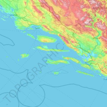
Name: Split-Dalmatia County topographic map, elevation, terrain.
Location: Split-Dalmatia County, Croatia (42.17660 15.18586 43.97399 17.45085)
Average elevation: 255 m
Minimum elevation: -5 m
Maximum elevation: 2,177 m
Other topographic maps
Click on a map to view its topography, its elevation and its terrain.
Staro Petrovo Selo
Croatia > Brod-Posavina County
It is located between the southern slopes of the Požeška gora mountain and the Sava river plain in the region of Slavonia, 12 km (7.5 mi) southeast of Nova Gradiška, at an elevation of 91 m.
Average elevation: 128 m
Šuškovići
Croatia > Sisak-Moslavina County > Town of Petrinja > Grabovac Banski
Average elevation: 214 m