
Batman topographic map
Interactive map
Click on the map to display elevation.
About this map
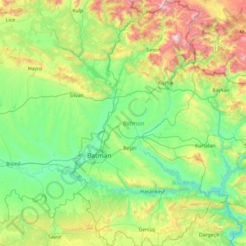
Name: Batman topographic map, elevation, terrain.
Location: Batman, Southeastern Anatolia Region, Turkey (37.49516 40.98644 38.54212 41.82192)
Average elevation: 941 m
Minimum elevation: 407 m
Maximum elevation: 2,929 m
The province lies in the mountainous area with the average elevation of 550 meters which contains several thousands of caves. The tallest mountains are Sason Dağları (2500 m), Meleto (2967 m), Kuşaklı Dağı (1947 m), Avcı Dağı (2121 m), Meydanok Tepesi (2042 m), Kortepe (2082 m) and Raman Dağı (1288 m). Several rivers (Turkish: Çay or Nehir) flow through the province, including Tigris, Batman, Sason and Garzan. The 115 km (71 mi) long Batman River flowing approximately from north to south forms a natural border between the Batman Province and Diyarbakır Province lying to the west. The historic Malabadi Bridge (built in 1146–1147) crosses the river near the town of Silvan. The Tigris flows from west to east, merges with the Batman River and exits the province. The Garzan River flowing from north to south enters the Tigris and separates Batman from the Siirt Province lying to the east. The province is also of interest from an archaeological point of view. Sights include the Imam Abdullah Dervish monastery, the bridge of Camiü‘r Rızk and Hasankeyf.
Other topographic maps
Click on a map to view its topography, its elevation and its terrain.
Alaçatı Mahallesi
Alaçatı Mahallesi, Çeşme, Izmir, Aegean Region, Turkey
Average elevation: 40 m
Balbey Mahallesi
Balbey Mahallesi, Antalya, Muratpaşa, Antalya, Mediterranean Region, Turkey
Average elevation: 43 m
Sığacık Mahallesi
Sığacık Mahallesi, Bozova, Şanlıurfa, Southeastern Anatolia Region, Turkey
Average elevation: 523 m
DF
Turkey > Borçka > Goman Yaylası
DF, Goman Yaylası, Borçka, Artvin, Black Sea Region, Turkey
Average elevation: 2,157 m
Gençlik Parkı
Gençlik Parkı, Hacı Bayram Mahallesi, Altındağ, Ankara, Central Anatolia Region, Turkey
Average elevation: 870 m
Polonezköy Mahallesi
Polonezköy Mahallesi, Beykoz, Istanbul, Marmara Region, Turkey
Average elevation: 147 m
Kuşsaray
Kuşsaray, Çorum Merkez, Çorum, Black Sea Region, Turkey
Average elevation: 1,129 m
İskele Mahallesi
İskele Mahallesi, Urla, Izmir, Aegean Region, Turkey
Average elevation: 55 m
Karahacılı
Karahacılı, Silifke, Mersin, Mediterranean Region, Turkey
Average elevation: 362 m
Kocatepe Mahallesi
Kocatepe Mahallesi, Çankaya, Ankara, Central Anatolia Region, 06660, Turkey
Average elevation: 896 m
Cappadocia
Turkey > Central Anatolia Region > Göreme
Cappadocia, Göreme, Nevşehir merkez, Nevşehir, Central Anatolia Region, 50650, Turkey
Average elevation: 1,144 m
Çıralı obruğu
Çıralı obruğu, Karapınar, Konya, Central Anatolia Region, Turkey
Average elevation: 1,048 m
Kümperli
Kümperli, Onikişubat, Kahramanmaraş, Mediterranean Region, Turkey
Average elevation: 1,116 m
Gülbahçe Mahallesi
Gülbahçe Mahallesi, Urla, Izmir, Aegean Region, 35433, Turkey
Average elevation: 93 m
Harbiye Mahallesi
Harbiye Mahallesi, Çankaya, Ankara, Central Anatolia Region, Turkey
Average elevation: 1,004 m
Yukarı Çanlı
Yukarı Çanlı, Kızılcahamam, Ankara, Central Anatolia Region, Turkey
Average elevation: 1,413 m
Kızılcapınar
Kızılcapınar, Adıyaman, Southeastern Anatolia Region, Turkey
Average elevation: 591 m
Taşlıbayır
Taşlıbayır, Aksicim, Vize, Kırklareli, Marmara Region, Turkey
Average elevation: 155 m
Etiler Mahallesi
Etiler Mahallesi, Kırıkkale, Central Anatolia Region, Turkey
Average elevation: 803 m