
Oleśnica County topographic map
Interactive map
Click on the map to display elevation.
About this map
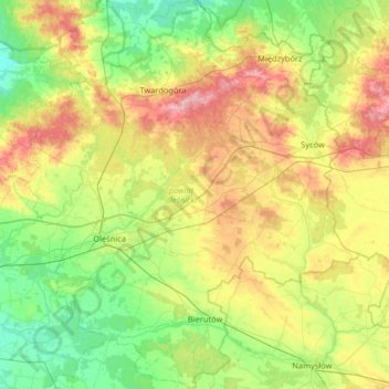
Name: Oleśnica County topographic map, elevation, terrain.
Location: Oleśnica County, Lower Silesian Voivodeship, Poland (51.05153 17.23824 51.45766 17.79527)
Average elevation: 163 m
Minimum elevation: 108 m
Maximum elevation: 267 m
Other topographic maps
Click on a map to view its topography, its elevation and its terrain.
Sokolik Duży
Poland > Lower Silesian Voivodeship > Karkonosze County > Bobrów
Average elevation: 431 m
Wojcieszyce Dolne
Poland > Lower Silesian Voivodeship > Karkonosze County > Wojcieszyce
Average elevation: 407 m
Węglówka
Poland > Lower Silesian Voivodeship > Ząbkowice Śląskie County > Opolnica
Average elevation: 391 m
Zamek Grodziec
Poland > Lower Silesian Voivodeship > Złotoryja County > Grodziec
Average elevation: 269 m
Śnieżka / Sněžka
Poland > Lower Silesian Voivodeship > Karkonosze County > Karpacz
Due to high altitude the climate is maritime polar (Köppen: ET) not far from a continental subpolar climate (Dfc). The difference should be at least 6 °C lower on annual average compared to the weather station in the plains.
Average elevation: 1,262 m
Karkonosze
Poland > Lower Silesian Voivodeship > Jelenia Góra
The Giant Mountains, Krkonoše, or Karkonosze (Czech: [ˈkr̩konoʃɛ] , Polish pronunciation: [karkɔˈnɔʂɛ] , German: Riesengebirge pronounced [ˈʁiːzn̩ɡəˌbɪʁɡə] ), are a mountain range located in the north of the Czech Republic and the south-west of Poland, part of the Sudetes mountain system…
Average elevation: 1,196 m
Bystrzyca Kłodzka
Poland > Lower Silesian Voivodeship > Kłodzko County > Bystrzyca Kłodzka > Bystrzyca Kłodzka
Average elevation: 404 m