
South Banat Administrative District topographic map
Interactive map
Click on the map to display elevation.
About this map
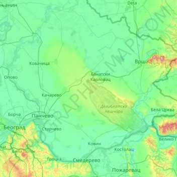
Name: South Banat Administrative District topographic map, elevation, terrain.
Location: South Banat Administrative District, Vojvodina, Serbia (44.65741 20.40891 45.33193 21.56013)
Average elevation: 107 m
Minimum elevation: 43 m
Maximum elevation: 599 m
Other topographic maps
Click on a map to view its topography, its elevation and its terrain.
Пуцкарош
Serbia > Vojvodina > South Backa Administrative District > Petrovaradin
Average elevation: 112 m
Baranda
Serbia > Vojvodina > South Banat Administrative District > Opovo Municipality
Average elevation: 75 m
Цигански логор
Serbia > Vojvodina > Srem Administrative District > Lezimir > Багрењак
Average elevation: 309 m
Subotica
Serbia > Vojvodina > North Backa Administrative District
It is located in the Pannonian Basin at 46.07° North, 19.68° East, at the altitude of 109m, about 10 kilometres (6 miles) from the border with Hungary, and is the northernmost city in Serbia. Lake Palić is in the immediate vicinity of the city. Sand dunes area Subotička Peščara is located north of the…
Average elevation: 115 m
Брдеж до
Serbia > Vojvodina > Srem Administrative District > Indjija Municipality > Cortanovci
Average elevation: 215 m
Banstol
Serbia > Vojvodina > South Backa Administrative District > Sremski Karlovci Municipality
Average elevation: 222 m
Beska
Serbia > Vojvodina > Srem Administrative District > Indjija Municipality
Average elevation: 128 m
Indjija
Serbia > Vojvodina > Srem Administrative District > Indjija Municipality
Average elevation: 110 m
Maradik
Serbia > Vojvodina > Srem Administrative District > Indjija Municipality
Average elevation: 157 m
Stara Pazova
Serbia > Vojvodina > Srem Administrative District > Stara Pazova Municipality
Average elevation: 83 m
Bač
Serbia > Vojvodina > South Backa Administrative District > Bac Municipality
Average elevation: 83 m
Deronje
Serbia > Vojvodina > West Backa Administrative District > Odzaci Municipality
Average elevation: 83 m
Alibunar
Serbia > Vojvodina > South Banat Administrative District > Alibunar Municipality
Average elevation: 101 m
Senta
Serbia > Vojvodina > North Banat Administrative District > Senta Municipality
Average elevation: 80 m
Backi Jarak
Serbia > Vojvodina > South Backa Administrative District > Temerin Municipality
Average elevation: 81 m
Gudurički vrh
Serbia > Vojvodina > South Banat Administrative District > City of Vršac
Average elevation: 330 m
Fruška gora
Serbia > Vojvodina > South Backa Administrative District > Beocin Municipality
Average elevation: 437 m
Backi Petrovac
Serbia > Vojvodina > South Backa Administrative District > Backi Petrovac Municipality
Average elevation: 82 m
Apatin
Serbia > Vojvodina > West Backa Administrative District > Apatin Municipality
Average elevation: 85 m
Krnjesevci
Serbia > Vojvodina > Srem Administrative District > Stara Pazova Municipality
Average elevation: 76 m
Hajducica
Serbia > Vojvodina > South Banat Administrative District > Plandiste Municipality
Average elevation: 77 m
Zrenjanin
Serbia > Vojvodina > Central Banat Administrative District > Zrenjanin
Average elevation: 80 m
Sremska Kamenica
Serbia > Vojvodina > South Backa Administrative District > Novi Sad City > Sremska Kamenica
Average elevation: 130 m
Becej
Serbia > Vojvodina > South Backa Administrative District > Becej Municipality
Average elevation: 78 m
Sremski Karlovci
Serbia > Vojvodina > South Backa Administrative District > Sremski Karlovci Municipality > Sremski Karlovci
Average elevation: 130 m
Kula
Serbia > Vojvodina > West Backa Administrative District > Kula Municipality > Kula
Average elevation: 89 m