
Holloways Beach topographic map
Interactive map
Click on the map to display elevation.
About this map
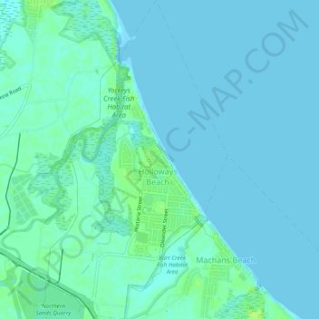
Name: Holloways Beach topographic map, elevation, terrain.
Location: Holloways Beach, Cairns Regional, Queensland, Australia (-16.85998 145.71500 -16.81487 145.74830)
Average elevation: 3 m
Minimum elevation: 0 m
Maximum elevation: 13 m
Other topographic maps
Click on a map to view its topography, its elevation and its terrain.
Sunshine Coast
Australia > Queensland > Sunshine Coast Regional
The Sunshine Coast in Queensland, Australia, showcases a diverse topography that harmoniously blends coastal plains with rugged hinterlands. Along its eastern edge, the region features expansive sandy beaches and coastal dunes that transition smoothly into fertile lowlands. Inland, the terrain becomes more…
Average elevation: 109 m
Gatton
Australia > Queensland > Gatton
The area has a humid subtropical climate, with hot, humid summers and mild, sunny winters. Heavy summer rain and warm conditions have provided ideal conditions for the areas agricultural productivity, although droughts and heatwaves can be problematic at times. Temperatures in Gatton are among the warmest in…
Average elevation: 115 m
Toowoomba
The city occupies the edge of the range and the low ridges behind it. Two valleys run north from the southern boundary, each arising from springs either side of Middle Ridge near Spring Street at an altitude of around 680 m. These waterways, East Creek and West Creek, flow together just north of the CBD to…
Average elevation: 458 m