
New Hampshire topographic map
Interactive map
Click on the map to display elevation.
New Hampshire
Average daytime highs are in the mid 70s°F to low 80s°F (24–28 °C) throughout the state in July, with overnight lows in the mid 50s°F to low 60s°F (13–15 °C). January temperatures range from an average high of 34 °F (1 °C) on the coast to overnight lows below 0 °F (−18 °C) in the far north and at high elevations. Average annual precipitation statewide is roughly 40 inches (100 cm) with some variation occurring in the White Mountains due to differences in elevation and annual snowfall. New Hampshire's highest recorded temperature was 106 °F (41 °C) in Nashua on July 4, 1911, while the lowest recorded temperature was −47 °F (−44 °C) atop Mount Washington on January 29, 1934. Mount Washington also saw an unofficial −50 °F (−46 °C) reading on January 22, 1885, which, if made official, would tie the record low for New England (also −50 °F (−46 °C) at Big Black River, Maine, on January 16, 2009, and Bloomfield, Vermont on December 30, 1933).
About this map
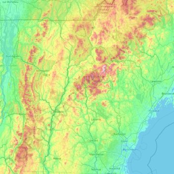
Name: New Hampshire topographic map, elevation, terrain.
Location: New Hampshire, United States (42.69723 -72.55724 45.30578 -70.56136)
Average elevation: 293 m
Minimum elevation: -4 m
Maximum elevation: 1,693 m
Other topographic maps
Click on a map to view its topography, its elevation and its terrain.
Georgetown
United States > Texas > Georgetown
The city is located on the northeastern edge of Texas Hill Country. Portions of Georgetown are located on either side of the Balcones Escarpment, a fault line in which the areas roughly east of IH-35 are flat and characterized by having black, fertile soils of the Blackland Prairie, and the west side of the…
Average elevation: 219 m
Baltimore
United States > Maryland > Baltimore
Baltimore is in north-central Maryland on the Patapsco River close to where it empties into the Chesapeake Bay. The city is also located on the fall line between the Piedmont Plateau and the Atlantic coastal plain, which divides Baltimore into "lower city" and "upper city". The city's elevation ranges from sea…
Average elevation: 65 m
San Diego
United States > California > San Diego County > San Diego
The climate in San Diego, like most of Southern California, often varies significantly over short geographical distances, resulting in microclimates. In San Diego, this is mostly because of the city's topography (the Bay, and the numerous hills, mountains, and canyons). Frequently, particularly during the "May…
Average elevation: 57 m
Scottsdale
United States > Arizona > Maricopa County > Scottsdale
The city is in the Salt River Valley, or the "Valley of the Sun," in the northern reaches of the Sonoran Desert. Scottsdale, 31 mi (50 km) long and 11.4 mi (18.3 km) wide at its widest point, shares boundaries with many other municipalities and entities. On the west, Scottsdale is bordered by Phoenix, Paradise…
Average elevation: 414 m
Crested Butte
United States > Colorado > Gunnison County
Crested Butte is located in north-central Gunnison County on the west side of the valley of the Slate River, along Coal Creek. Colorado State Highway 135 runs south from Crested Butte 27 miles (43 km) to Gunnison, the county seat. According to the United States Census Bureau, the town of Crested Butte has a…
Average elevation: 2,798 m
Appalachian Mountains
United States > North Carolina > Yancey County
The Appalachian Mountains (French: Appalaches), often called the Appalachians, are a system of mountains in eastern to northeastern North America. The Appalachians first formed roughly 480 million years ago during the Ordovician Period. They once reached elevations similar to those of the Alps and the Rocky…
Average elevation: 1,463 m
Indianapolis
United States > Indiana > Indianapolis
Indianapolis is within the Tipton Till Plain, a flat to gently sloping terrain underlain by glacial deposits known as till. The lowest point in the city is about 650 feet (198 m) above mean sea level, with the highest natural elevation at about 900 feet (274 m) above sea level. Few hills or short ridges, known…
Average elevation: 241 m
Mason-Dixon Historical Park
United States > West Virginia > Monongalia County > Holman
Average elevation: 330 m
Columbus
United States > Ohio > Franklin County > Columbus
The confluence of the Scioto and Olentangy rivers is just north-west of Downtown Columbus. Several smaller tributaries course through the Columbus metropolitan area, including Alum Creek, Big Walnut Creek, and Darby Creek. Columbus is considered to have relatively flat topography thanks to a large glacier that…
Average elevation: 255 m
Central Park
United States > New York > New York County > New York
In June 1856, Fernando Wood appointed a "consulting board" of seven people, headed by author Washington Irving, to inspire public confidence in the proposed development. Wood hired military engineer Egbert Ludovicus Viele as the park's chief engineer, tasking him with a topographical survey of the site. The…
Average elevation: 26 m
Estes Park
United States > Colorado > Larimer County
Estes Park sits at an elevation of 7,522 feet (2,293 m) on the front range of the Rocky Mountains at the eastern entrance of the Rocky Mountain National Park. Its north, south and east extremities border the Roosevelt National Forest. Lumpy Ridge lies immediately north of Estes Park.
Average elevation: 2,543 m
Port Charlotte
United States > Florida > Charlotte County
Port Charlotte is characterized by a predominantly flat and low-lying terrain, typical of Florida’s coastal landscape. The area features a network of waterways, including the Peace River and Charlotte Harbor, which provide ample opportunities for recreational activities like boating and fishing. Elevations…
Average elevation: 4 m
Appalachian Mountains
United States > North Carolina > Yancey County
The Appalachian Mountains (French: Appalaches), often called the Appalachians, are a system of mountains in eastern to northeastern North America. The Appalachians first formed roughly 480 million years ago during the Ordovician Period. They once reached elevations similar to those of the Alps and the Rocky…
Average elevation: 1,463 m
Bacliff
United States > Texas > Galveston County
After Hurricane Ike hit Texas in September 2008, Galveston County officials offered a debris removal program to residents in unincorporated areas, including Bacliff. Flooding from hurricane Ike was minimized due in part to Bacliff's relatively high elevation of 16 feet.
Average elevation: 4 m
Elmer B Boyd Park
United States > New Jersey > Middlesex County > New Brunswick > Feaster Park
Average elevation: 22 m
Nokomis
United States > Florida > Sarasota County
Nokomis features a predominantly flat and low-lying terrain characteristic of the coastal region. The elevation in Nokomis rarely exceeds 15 feet above sea level, contributing to its vulnerability to tidal influences and storm surges. The area is interspersed with wetlands and mangroves, particularly near the…
Average elevation: 5 m
Mauna Loa
United States > Hawaii > Hawaiʻi County
Mauna Loa is the largest subaerial and second largest overall volcano in the world (behind Tamu Massif), covering a land area of 5,271 km2 (2,035 sq mi) and spans a maximum width of 120 km (75 mi). Consisting of approximately 65,000 to 80,000 km3 (15,600 to 19,200 cu mi) of solid rock, it makes up more than…
Average elevation: 4,037 m
Skinnies Lake
United States > Michigan > Marquette County > Humboldt Township
Average elevation: 453 m
Country Club Estates
United States > North Carolina > Alamance County > Burlington
Average elevation: 195 m
Navarre
United States > Florida > Santa Rosa County
Navarre is located at 30°24′04″N 86°51′47″W / 30.401°N 86.863°W / 30.401; -86.863Coordinates: 30°24′04″N 86°51′47″W / 30.401°N 86.863°W / 30.401; -86.863. It is located within a portion of the Florida Panhandle observing the Central Time Zone. Elevation is at an average of 10 feet (3.0 m).
Average elevation: 4 m
Palm Harbor
United States > Florida > Pinellas County
Palm Harbor is characterized by its unique topography, which features a relatively rare hilly landscape for the region. Unlike much of the surrounding areas in Pinellas County, which are predominantly flat, Palm Harbor includes elevations that can reach up to about 75 feet above sea level. This elevation gives…
Average elevation: 9 m
Oakhurst
United States > California > Madera County > Oakhurst
Oakhurst is located on the Fresno River 3 miles (5 km) south-southwest of Yosemite Forks, at an elevation of 2,274 feet (693 m). Its coordinates are 37°19′41″N 119°38′58″W / 37.32806°N 119.64944°W / 37.32806; -119.64944. It is located at the junction of state highways 41 and 49, at the…
Average elevation: 837 m
Virginia Beach
United States > Virginia > Virginia Beach
According to the United States Census Bureau, the city has a total area of 497 square miles (1,290 km2), of which 249 square miles (640 km2) is land and 248 square miles (640 km2) (49.9%) is water. It is the largest city in Virginia by total area and third-largest city land area. The average elevation is 12…
Average elevation: 2 m
Evergreen
United States > Colorado > Jefferson County
Evergreen sits at an elevation of 7,220 feet (2,200 m) in the Rocky Mountains, 19 miles west of Denver, Colorado. Its addresses are oriented according to the Street_system_of_Denver.
Average elevation: 2,309 m
Mount Shasta
United States > California > Siskiyou County
Mount Shasta (Shasta: Waka-nunee-Tuki-wuki; Karuk: Úytaahkoo) is a potentially active volcano at the southern end of the Cascade Range in Siskiyou County, California. At an elevation of 14,179 feet (4,321.8 meters), it is the second-highest peak in the Cascades and the fifth-highest in the state. Mount Shasta…
Average elevation: 3,717 m
Rawsonville
United States > Michigan > Washtenaw County > Ypsilanti Charter Township
Average elevation: 214 m
Countryside Mobile Home Park
United States > Minnesota > Pennington County > Thief River Falls
Average elevation: 344 m
Saint Elmo
United States > Colorado > Chaffee County
Saint Elmo is a ghost town in Chaffee County, Colorado, United States. Founded in 1880, Saint Elmo lies in the heart of the Sawatch Range, 20 miles (32 km) southwest of Buena Vista and sits at an elevation of 9,961 feet (3,036 m). Nearly 2,000 people settled in this town when mining for gold and silver…
Average elevation: 3,247 m
Smithville
United States > Pennsylvania > Lancaster County > Providence Township
Average elevation: 140 m
Highlands
United States > North Carolina > Macon County > Highlands
Highlands was founded in 1875 after its two founders, Samuel Truman Kelsey and Clinton Carter Hutchinson, drew lines from Chicago to Savannah and from New Orleans to New York City. They felt that the place where these lines met would eventually become a great trading center and commercial crossroads. Highlands…
Average elevation: 1,090 m
Mount Rushmore
United States > South Dakota > Pennington County
Mount Rushmore National Memorial is centered on a colossal sculpture carved into the granite face of Mount Rushmore (Lakota: Tȟuŋkášila Šákpe, or Six Grandfathers) in the Black Hills near Keystone, South Dakota. Sculptor Gutzon Borglum created the sculpture's design and oversaw the project's execution…
Average elevation: 1,562 m
Wesley Chapel
United States > Florida > Pasco County
According to the United States Census Bureau, the CDP has a total area of 6.1 square miles (16 km2), of which 6.1 square miles (16 km2) is land and 0.04 square miles (0.10 km2) (0.49%) is water. The elevation is about 100 feet (30 m), combined with an inland location, creates more temperature variation in the…
Average elevation: 19 m
San Francisco Bay Area
United States > California > San Francisco
The San Francisco Bay Area is characterized by a diverse and dynamic topography shaped by geological processes over millions of years. This region features a combination of coastal plains, steep hills, and rugged mountains, all influenced by the tectonic activity associated with the nearby San Andreas Fault…
Average elevation: 113 m
Florida Keys
United States > Florida > Monroe County
Tropical cyclones present special dangers and challenges to the entire Keys. Because no area of the islands is more than 20 feet (6.1 m) above sea level (and many are only a few feet elevation), and water surrounds the islands, nearly every neighborhood is subject to flooding as well as hurricane winds. In…
Average elevation: 0 m
Laytonville
United States > California > Mendocino County > Laytonville
Laytonville is a census-designated place (CDP) in Mendocino County, California, United States. It is located 23 miles (37 km) north-northwest of Willits, at an elevation of 1,670 feet (510 m). The population was 1,152 at the 2020 census, down from 1,227 at the 2010 census.
Average elevation: 536 m