
Åland Islands topographic map
Interactive map
Click on the map to display elevation.
About this map
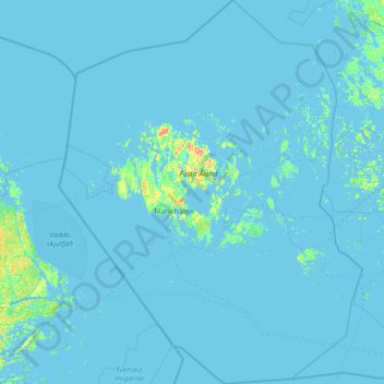
Name: Åland Islands topographic map, elevation, terrain.
Location: Åland Islands, Finland (59.45416 19.08320 60.87665 21.34565)
Average elevation: 2 m
Minimum elevation: -4 m
Maximum elevation: 117 m
Other topographic maps
Click on a map to view its topography, its elevation and its terrain.
Huopanankoski
Finland > Central Finland > Viitasaari > Huopanankoski
Huopana is located on the waterway from Lake Kivijärvi to Lake Keitele. The rapids consist of a narrow forked stream flowing from Lake Vuosjärvi to Lake Muuruejärvi with a total elevation difference of 6.5 metres (21 ft). The left fork of the rapids is in a nearly natural state. The right fork has been…
Average elevation: 108 m
Kilpisjärvi
Although Kilpisjärvi is one of the largest villages in Enontekiö, it is still quite small. In 2000 its population was recorded as 114. Like most Sami villages, Kilpisjärvi is built mainly around one major road, Käsivarrentie, or the "Arm Road" and Neljäntuulentie, or the "Four Winds' Road" — also known…
Average elevation: 527 m