Geolocate

Chippewa County topographic map

Interactive map

Click on the map to display elevation.

About this map

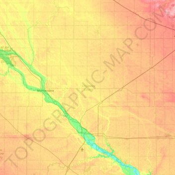
Name: Chippewa County topographic map, elevation, terrain.

Location: Chippewa County, Minnesota, United States (44.75067 -96.04185 45.15281 -95.24632)

Average elevation: 319 m

Minimum elevation: 261 m

Maximum elevation: 378 m

Other topographic maps

Click on a map to view its topography, its elevation and its terrain.

Makinen

United States > Minnesota > Saint Louis County

Average elevation: 420 m

Gladstone

United States > Minnesota > Ramsey County > Maplewood

Average elevation: 285 m

Northdale

United States > Minnesota > Anoka County > Coon Rapids

Average elevation: 271 m

Lake George

United States > Minnesota > Hubbard County

Average elevation: 435 m

Island Lake

United States > Minnesota > Anoka County > Linwood

Average elevation: 277 m

Ruthruff

United States > Minnesota > Clay County

Average elevation: 279 m

Conception

United States > Minnesota > Wabasha County

Average elevation: 338 m

Zim

United States > Minnesota > Saint Louis County

Average elevation: 408 m

Rapidan

United States > Minnesota > Blue Earth County

Average elevation: 299 m

Dislocation Lake

United States > Minnesota > Cook County

Average elevation: 575 m

Wolverton WMA

United States > Minnesota > Wilkin County

Average elevation: 284 m

Lutsen

United States > Minnesota > Cook County

Average elevation: 225 m

Hum Lake

United States > Minnesota > Lake County

Average elevation: 468 m

Ruth Lake

United States > Minnesota > Crow Wing County > Emily

Average elevation: 391 m

Rum River

United States > Minnesota > Anoka County > Anoka

Average elevation: 265 m

Castle Danger

United States > Minnesota > Lake County

Average elevation: 212 m

Elizabeth Lake

United States > Minnesota > Isanti County

Average elevation: 286 m

Fan Lake

United States > Minnesota > Cook County

Average elevation: 535 m

Eagle Mountain

United States > Minnesota > Cook County

Eagle Mountain is only about 15 miles (24 km) from Minnesota's lowest elevation, Lake Superior, at 600 feet (183 m). It is part of the Canadian Shield. Confusingly, there is another much shorter peak also named Eagle Mountain in northern Minnesota. The shorter peak is part of the Lutsen Mountains ski resort.

Average elevation: 596 m

Luce

United States > Minnesota > Otter Tail County

Average elevation: 419 m

Saint Henry

United States > Minnesota > Le Sueur County

Average elevation: 307 m

Heath Creek

United States > Minnesota > Rice County > Northfield

Average elevation: 292 m

Griddle Lake

United States > Minnesota > Lake County

Average elevation: 444 m

Candy Lake

United States > Minnesota > Itasca County

Average elevation: 421 m

Britt

United States > Minnesota > Saint Louis County

Average elevation: 448 m

Lutsen

United States > Minnesota > Cook County

Average elevation: 225 m

Welch

United States > Minnesota > Goodhue County

Average elevation: 277 m

Avon Beach

United States > Minnesota > Stearns County > Avon

Average elevation: 344 m

Snowden

United States > Minnesota > Saint Louis County > Eveleth

Average elevation: 458 m

Shorewood

United States > Minnesota > Hennepin County > Tonka Bay

Average elevation: 292 m

Northfield

United States > Minnesota > Rice County

Average elevation: 300 m

Carver

United States > Minnesota > Carver County > Carver > Carver

Average elevation: 242 m

Saint Cloud

United States > Minnesota > Benton County

Average elevation: 314 m

Farming

United States > Minnesota > Stearns County

Average elevation: 362 m

Empire Lake

United States > Minnesota > Dakota County

Average elevation: 277 m

Rum River

United States > Minnesota > Isanti County > Walbo

Average elevation: 287 m

Embarrass

United States > Minnesota > Saint Louis County

Average elevation: 438 m

Shakopee

United States > Minnesota > Scott County > Shakopee > Shakopee

Average elevation: 248 m

Savage

United States > Minnesota > Scott County > Savage > Savage

Average elevation: 251 m

Orrock

United States > Minnesota > Sherburne County > Orrock

Average elevation: 298 m

Pickwick

United States > Minnesota > Winona County

Average elevation: 278 m

Coates

United States > Minnesota > Dakota County > Coates > Coates

Average elevation: 280 m

Eagle Mountain

United States > Minnesota > Cook County

Eagle Mountain is only about 12 miles (19 km) from Minnesota's lowest elevation, Lake Superior, at 600 feet (183 m). It is part of the Canadian Shield. There is also another much shorter peak also named Eagle Mountain in northern Minnesota. The shorter peak is part of the Lutsen Mountains ski resort.

Average elevation: 596 m

Richfield

United States > Minnesota > Hennepin County > Richfield

Average elevation: 259 m

Fairmont

United States > Minnesota > Martin County > Fairmont > Fairmont

Average elevation: 360 m

Ely

United States > Minnesota > Saint Louis County > Ely > Ely

Average elevation: 433 m

Bemidji

United States > Minnesota > Beltrami County > Bemidji

Average elevation: 416 m

Dexter

United States > Minnesota > Dexter

Average elevation: 427 m

Harrison Township

United States > Minnesota

Average elevation: 363 m

Schmidt Lake

United States > Minnesota > Plymouth

Average elevation: 287 m

Kelly Lake

United States > Minnesota > Hibbing > Kelly Lake

Average elevation: 467 m

Bass Creek

United States > Minnesota > Plymouth

Average elevation: 282 m

Olso Lake

United States > Minnesota > Cook County

Average elevation: 544 m