
Aden Governorate topographic map
Interactive map
Click on the map to display elevation.
About this map
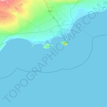
Name: Aden Governorate topographic map, elevation, terrain.
Location: Aden Governorate, Yemen (12.43190 44.31791 12.94122 45.26676)
Average elevation: 41 m
Minimum elevation: -4 m
Maximum elevation: 771 m
Other topographic maps
Click on a map to view its topography, its elevation and its terrain.
Hodeidah
Yemen > Al Hudaydah Governorate
Mountain Highlands: Notable mountains include Jabal Ras and Jabal Bura, both reaching elevations of 2,000 to 2,400 meters above sea level.
Average elevation: 16 m
Hodeidah
Yemen > Al Hudaydah Governorate
Mountain Highlands: Notable mountains include Jabal Ras and Jabal Bura, both reaching elevations of 2,000 to 2,400 meters above sea level.
Average elevation: 16 m
Ta'izz
Taiz (Arabic: تَعِزّ, romanized: Taʿizz) is a city in southwestern Yemen. It is located in the Yemeni highlands, near the port city of Mocha on the Red Sea, at an elevation of about 1,400 metres (4,600 ft) above sea level. It is the capital of Taiz Governorate. As of 2023, the city has an estimated…
Average elevation: 1,416 m