
Waupaca County topographic map
Interactive map
Click on the map to display elevation.
About this map
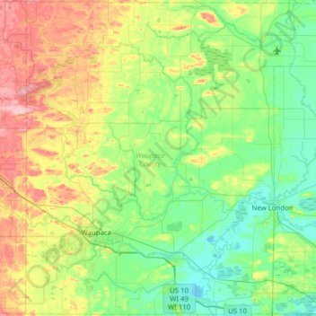
Name: Waupaca County topographic map, elevation, terrain.
Location: Waupaca County, Wisconsin, United States (44.24247 -89.22473 44.68147 -88.60509)
Average elevation: 272 m
Minimum elevation: 226 m
Maximum elevation: 384 m
Other topographic maps
Click on a map to view its topography, its elevation and its terrain.
Observatory Hill State Natural Area
United States > Wisconsin > Marquette County
Average elevation: 262 m
McAllister
United States > Wisconsin > Marinette County
McAllister is located at the intersection of Wisconsin Highway 180 and County Highway JJ 11.5 miles (18.5 km) east-southeast of Wausaukee at an elevation of 692 feet (211 m). It is connected by road to Wausaukee to the west, Packard to the north, Wagner to the south, and Wallace, Michigan, to the east via a…
Average elevation: 210 m
Wilderness Lake
United States > Wisconsin > Bayfield County > Town of Drummond
Average elevation: 391 m
Milwaukee River Floodplain Forest State Natural Area
United States > Wisconsin > Washington County
Average elevation: 291 m
Marinette County Beech Forest State Natural Area
United States > Wisconsin > Marinette County
Average elevation: 371 m
Isthmus Path Prairie Garden
United States > Wisconsin > Dane County > Madison
Average elevation: 262 m
Yellowstone Lake State Park
United States > Wisconsin > Lafayette County > Blanchardville > Town of Fayette
Average elevation: 288 m
Village of West Salem
United States > Wisconsin > La Crosse County > West Salem
Average elevation: 226 m
Black River Falls
United States > Wisconsin > Jackson County > Black River Falls
Average elevation: 264 m
Menomonee Falls
United States > Wisconsin > Waukesha County > Menomonee Falls
Average elevation: 260 m
Allenton
United States > Wisconsin > Washington County
Allenton is located at latitude 43.421 and longitude -88.341. The elevation is 958 feet. Allenton has an area of 1.446 square miles (3.75 km2), all of it land. The Rock River cuts through the town.
Average elevation: 313 m
Madison
United States > Wisconsin > Madison
The city is sometimes described as The City of Four Lakes, comprising the four successive lakes of the Yahara River: Lake Mendota ("Fourth Lake"), Lake Monona ("Third Lake"), Lake Waubesa ("Second Lake") and Lake Kegonsa ("First Lake"), although Waubesa and Kegonsa are not actually in Madison, but just south…
Average elevation: 289 m
Pleasant Prairie
United States > Wisconsin > Kenosha County > Pleasant Prairie
Average elevation: 218 m
Bypass Channel Wisconsin River
United States > Wisconsin > Marathon County > Wausau
Average elevation: 371 m