
Zaragoza topographic map
Interactive map
Click on the map to display elevation.
Zaragoza
On 1 January 2019 the population of the city of Zaragoza was 706,904, within its administrative limits on a land area of 1,062.64 square kilometres (410.29 square miles), ranking fifth in Spain. It is the 32nd most populous municipality in the European Union. The population of the metropolitan area was estimated in 2006 at 783,763 inhabitants. The municipality is home to more than 50 percent of the Aragonese population. The city lies at an elevation of 199 metres (653 feet) above sea level.
About this map
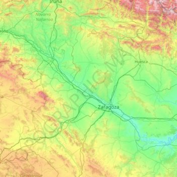
Name: Zaragoza topographic map, elevation, terrain.
Location: Zaragoza, Aragon, Spain (40.93622 -2.17367 42.74413 0.38566)
Average elevation: 701 m
Minimum elevation: 110 m
Maximum elevation: 3,187 m
Other topographic maps
Click on a map to view its topography, its elevation and its terrain.
Vitales
Spain > Aragon > Hoya de Huesca / Plana de Uesca > Monflorite-Lascasas
Average elevation: 492 m
Sistema Ibérico
Spain > Aragon > Tarazona y el Moncayo > Tarazona
The geology of the Iberian System is complex, for it can hardly be defined as a homogeneous system. It is composed of a haphazard and motley series of mountain ranges, massifs, plateaus and depressions without a definite common petrologic composition and overall structure. Nummulite limestone, marble and…
Average elevation: 1,906 m
Riglos
Spain > Aragon > Hoya de Huesca / Plana de Uesca > Las Peñas de Riglos
Average elevation: 726 m
Pla de Beronia
Spain > Aragon > Bajo Aragón-Caspe / Baix Aragó-Casp > Fabara / Favara
Average elevation: 215 m
Huesca
Huesca lies on a plateau in the northern region of Aragón, with an elevation of 488 m (1,601.05 ft) above sea level. Close to the city lie the Sierra de Guara mountains, which reach 2,077 m. The geographical coordinates of the city are: 42° 08´ N, 0° 24´ W.
Average elevation: 589 m