County Wexford topographic map
Interactive map
Click on the map to display elevation.
About this map
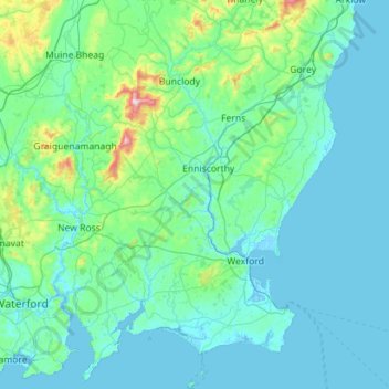
Name: County Wexford topographic map, elevation, terrain.
Location: County Wexford, Leinster, Ireland (52.10885 -7.01781 52.79746 -6.14069)
Average elevation: 63 m
Minimum elevation: -4 m
Maximum elevation: 784 m
Other topographic maps
Click on a map to view its topography, its elevation and its terrain.
Carrick-on-Shannon
Carrick-on-Shannon, County Leitrim, Connacht, Ireland
Average elevation: 48 m
Mountmellick
Mountmellick, The Municipal District of Borris-in-Ossory — Mountmellick, County Laois, Leinster, Ireland
Average elevation: 76 m
Crocknafeola
Crocknafeola, Killybegs ED, Donegal Municipal District, County Donegal, Ireland
Average elevation: 111 m
Myrtleville Beach
Myrtleville Beach, Templebreedy, Municipal District of Carrigaline, County Cork, Munster, Ireland
Average elevation: 32 m
Glenamaddy
Glenamaddy, Ballinasloe Municipal District, County Galway, Connacht, Ireland
Average elevation: 85 m
Aughrim
Aughrim, The Municipal District of Arklow, County Wicklow, Leinster, Y14 HT72, Ireland
Average elevation: 123 m
Vartry Reservoir Lower
Vartry Reservoir Lower, Altidore ED, The Municipal District of Wicklow, County Wicklow, Leinster, Ireland
Average elevation: 229 m
Carndonagh
Carndonagh, Inishowen Municipal District, County Donegal, Ireland
Average elevation: 54 m
Rockfort
Rockfort, Brinny ED, The Municipal District of Bandon-Kinsale, County Cork, Munster, Ireland
Average elevation: 53 m
Ballintogher
Ballintogher, Rathfeston ED, The Municipal District of Edenderry, County Offaly, Leinster, Ireland
Average elevation: 86 m
Ballintogher
Ballintogher, Sligo Municipal Borough District, County Sligo, Connacht, Ireland
Average elevation: 64 m
Killinkere
Killinkere, Bailieborough-Cootehill Municipal District, County Cavan, A82 YN50, Ireland
Average elevation: 124 m
Aghafin
Aghafin, Noughaval ED, The Municipal District of Athlone — Moate, County Westmeath, Leinster, Ireland
Average elevation: 61 m
Beaufort
Beaufort, Dunloe ED, Kenmare Municipal District, County Kerry, Munster, Ireland
Average elevation: 38 m
Kilgarvan
Kilgarvan, Kilgarvan ED, Kenmare Municipal District, County Kerry, Munster, Ireland
Average elevation: 71 m
Mohill
Mohill, Mohill ED, Carrick-on-Shannon Municipal District, County Leitrim, Connacht, N41 R9T3, Ireland
Average elevation: 60 m
Allenwood
Allenwood, The Municipal District of Clane — Maynooth, County Kildare, Leinster, W91 XW6H, Ireland
Average elevation: 82 m
Yardland
Yardland, Arklow No 1 Urban ED, The Municipal District of Arklow, County Wicklow, Leinster, Ireland
Average elevation: 23 m
Ringaskiddy
Ringaskiddy, Municipal District of Carrigaline, County Cork, Munster, P43 A062, Ireland
Average elevation: 13 m
Corkey
Ireland > County Donegal > Letterkenny
Corkey, Kincraigy ED, Letterkenny, County Donegal, Ireland
Average elevation: 36 m
Doonbeakin
Doonbeakin, Templeboy South ED, Ballymote-Tubbercurry Municipal District, County Sligo, Connacht, Ireland
Average elevation: 106 m
Mallow
Mallow, The Municipal District of Kanturk-Mallow, County Cork, Munster, Ireland
Average elevation: 77 m
Dromana
Dromana, The Municipal District of Dungarvan — Lismore, County Waterford, Munster, Ireland
Average elevation: 34 m
Greencastle
Greencastle, Inishowen Municipal District, County Donegal, Ireland
Average elevation: 46 m
Butter Bridge
Butter Bridge, Ballyfoyle ED, Municipal District of Carrigaline, County Cork, Munster, P17 K725, Ireland
Average elevation: 70 m
Milford
Milford, The Municipal District of Kanturk-Mallow, County Cork, Munster, P56 PX32, Ireland
Average elevation: 119 m
Kilglass Lough
Kilglass Lough, Ballygarden ED, Boyle Municipal District, County Roscommon, Connacht, Ireland
Average elevation: 63 m
Killaloe Municipal District
Killaloe Municipal District, County Clare, Munster, Ireland
Average elevation: 85 m
Fossa
Fossa, Killarney Rural ED, Killarney Municipal District, County Kerry, Munster, Ireland
Average elevation: 42 m
Bridgetown
Bridgetown, The Borough District of Wexford, County Wexford, Leinster, Ireland
Average elevation: 10 m
Hamilton's Lock
Hamilton's Lock, Lusmagh ED, The Municipal District of Birr, County Offaly, Leinster, Ireland
Average elevation: 35 m
Kilmore East
Kilmore East, Scotstown Electoral Division, Monaghan Municipal District, County Monaghan, Ulster, Ireland
Average elevation: 74 m
Ballyogan
Ballyogan, Freaghana, The Municipal District of Callan — Thomastown, County Kilkenny, Leinster, Ireland
Average elevation: 130 m
Mullaghcleevaun
Mullaghcleevaun, The Municipal District of Wicklow, County Wicklow, Leinster, Ireland
Average elevation: 654 m
Ross Lake
Ross Lake, Sliabh an Aonaigh, Conamara Municipal District, County Galway, Connacht, Ireland
Average elevation: 17 m
Turlough Hill
Turlough Hill, West Clare Municipal District, County Clare, Munster, H91 K526, Ireland
Average elevation: 129 m
Rosapenna
Ireland > County Donegal > Letterkenny
Rosapenna, Rosguill ED, Letterkenny, County Donegal, Ireland
Average elevation: 11 m
Abbeyfield
Abbeyfield, Kilconnell ED, Ballinasloe Municipal District, County Galway, Connacht, Ireland
Average elevation: 92 m
Inishowen
Inishowen, Neale Electoral Division, Claremorris-Swinford Municipal District, County Mayo, Connacht, Ireland
Average elevation: 18 m
Slad
Slad, Kilscoran ED, The Borough District of Wexford, County Wexford, Leinster, Ireland
Average elevation: 21 m
Clone
Clone, Aughrim ED, The Municipal District of Arklow, County Wicklow, Leinster, Ireland
Average elevation: 172 m
Glenveagh National Park
Glenveagh National Park, Drumnalifferny Mountain, Dunlewy ED, Glenties Municipal District, County Donegal, Ulster, Ireland
Average elevation: 200 m
Beagh ED
Beagh ED, Loughrea Municipal District, County Galway, Connacht, Ireland
Average elevation: 34 m