
Rila mountain range topographic map
Interactive map
Click on the map to display elevation.
About this map
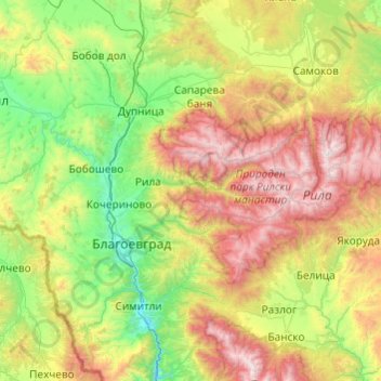
Name: Rila mountain range topographic map, elevation, terrain.
Location: Rila mountain range, Rila, Kyustendil, Bulgaria (41.87492 23.04781 42.34627 24.01531)
Average elevation: 1,105 m
Minimum elevation: 273 m
Maximum elevation: 2,899 m
Other topographic maps
Click on a map to view its topography, its elevation and its terrain.
Rila mountain range
Rila (Bulgarian: Рила, pronounced [ˈriɫɐ]) is the highest mountain range of Bulgaria, the Balkan Peninsula, and Southeast Europe. It is situated in southwestern Bulgaria and forms part of the Rila–Rhodope Massif. The highest summit is Musala at an elevation of 2,925 m which makes Rila the sixth…
Average elevation: 2,525 m
Vihren
Vihren (Bulgarian: Вихрен [ˈvixrɛn]) is the highest peak of Bulgaria's Pirin Mountains. Reaching 2,914 metres (9,560 ft), it is Bulgaria's second and the Balkans' third highest, after Musala and Mount Olympus. Although Vihren is deprived of lakes and streams due to the karst topography, a number of…
Average elevation: 2,442 m
Dobrinishte
Dobrinishte (Bulgarian: Добринище [dobˈriniʃtɛ]) is a small town and ski resort in the Blagoevgrad Province, Bansko Municipality, southwestern Bulgaria. As of 2006 it had 2973 inhabitants. It is located 6 km east of Bansko, a famous winter resort. It has an altitude of 850 m and is surrounded by…
Average elevation: 988 m
Belmeken
Belmeken (Bulgarian: Белмекен) is a summit in the northeastern part of the Rila Mountain in southwestern Bulgaria with a height of 2,626 m. It is built up of granite. Its northern slopes are steep and rise over the Kutlinite cirque. The southern and southeastern slopes are oblique. To the southeast at…
Average elevation: 2,300 m
Pasarel
Bulgaria > Sofia-City > Dolni Pasarel
The Pasarel dam and reservoir is located 20 km to the southeast of Sofia, Bulgaria at an altitude of 700 m.
Average elevation: 822 m
Bansko
Bansko (Bulgarian: Банско [ˈbansko]) is a town in southwestern Bulgaria, located at the foot of the Pirin Mountains at an elevation of 1200m above sea level. It is a ski resort.
Average elevation: 1,034 m
Laki
In 1889, Stefan Verkovic (Topographical and Ethnographic Essay of Macedonia) noted Lika (Laki) as a village with 63 Bulgarian and 18 Turkish houses.
Average elevation: 805 m