
Make a donation
Gear up for your next adventure:
As an Amazon Associate, this site earns from qualifying purchases at no extra cost to you.
River Irwell topographic map
Click on the map to display elevation.
Make a donation
Gear up for your next adventure:
As an Amazon Associate, this site earns from qualifying purchases at no extra cost to you.
River Irwell
The River Irwell catchment area extends from the moors above Bacup to the Manchester Ship Canal. The climate of the catchment area is wetter than the UK average, with rainfall of 1,456 millimetres (57.3 in) per annum compared to 1,231 millimetres (48.5 in) per annum, and the rivers quickly respond to rainfall. The topography varies considerably, with the upper reaches dominated by the Pennine moors at an altitude of between 350 and 450 metres (1,150 and 1,480 ft) AOD and the bottom of the catchment consisting of relatively flat land, which lies between 20 and 150 metres (66 and 492 ft) AOD. The watercourses are characterised by steep narrow valleys, which contributes to high rates of run-off, as does the underlying solid geology. This comprises Lower Coal Measures overlying Millstone Grit, both of which are classified as minor aquifers which will only hold relatively small amounts of water. The Millstone Grit is, in turn, underlain by limestone rocks from the lower Carboniferous period. The surface deposits comprise thick peat in the upper reaches, with glacial boulder clay and glacial sand and gravel in the lower parts. The sand and gravel are also classified as a minor aquifer, whilst the boulder clay is a non-aquifer. The higher, steeper slopes of the upper part of the catchment provide a large source of erodible material and debris which is transported downstream to the lower, flatter parts of the catchment. Where the channel is constricted, this material is then deposited and can contribute to a reduction in channel capacity.
Make a donation
Gear up for your next adventure:
As an Amazon Associate, this site earns from qualifying purchases at no extra cost to you.
About this map
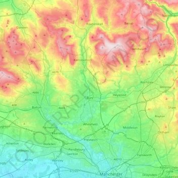
Name: River Irwell topographic map, elevation, terrain.
Average elevation: 178 m
Minimum elevation: 14 m
Maximum elevation: 477 m
Lancashire trails, hiking, mountain biking, running and outdoor activities
Make a donation
Gear up for your next adventure:
As an Amazon Associate, this site earns from qualifying purchases at no extra cost to you.
Other topographic maps
Click on a map to view its topography, its elevation and its terrain.
Make a donation
Gear up for your next adventure:
As an Amazon Associate, this site earns from qualifying purchases at no extra cost to you.
Bury Hey Wood
United Kingdom > England > Lancashire > West Lancashire > Appley Bridge > Robin Hood
Average elevation: 106 m
Make a donation
Gear up for your next adventure:
As an Amazon Associate, this site earns from qualifying purchases at no extra cost to you.
Accrington
United Kingdom > England > Lancashire > Hyndburn
Geographical coordinates: 53° 46' 0" North, 2° 21' 0" West. Height above sea level: there is a spot height outside the Market Hall which is 133.5 metres (438 ft) the benchmark on the side of the neighbouring Town Hall is 441.10 feet (134.45 m). The highest height in the town is 320 metres (1,050 ft) which is…
Average elevation: 199 m
Make a donation
Gear up for your next adventure:
As an Amazon Associate, this site earns from qualifying purchases at no extra cost to you.
Beach Lighthouse
United Kingdom > England > Lancashire > Borough of Wyre > Fleetwood
Average elevation: 3 m
Make a donation
Gear up for your next adventure:
As an Amazon Associate, this site earns from qualifying purchases at no extra cost to you.
Make a donation
Gear up for your next adventure:
As an Amazon Associate, this site earns from qualifying purchases at no extra cost to you.
Lad Law (Boulsworth Hill)
United Kingdom > England > Lancashire > Borough of Pendle
Average elevation: 409 m
Houghton Hagg Wood
United Kingdom > England > Lancashire > Burnley > Worsthorne
Average elevation: 192 m
Rake Head
United Kingdom > England > Lancashire > Borough of Rossendale > Stacksteads
Average elevation: 315 m
Make a donation
Gear up for your next adventure:
As an Amazon Associate, this site earns from qualifying purchases at no extra cost to you.
Make a donation
Gear up for your next adventure:
As an Amazon Associate, this site earns from qualifying purchases at no extra cost to you.
Make a donation
Gear up for your next adventure:
As an Amazon Associate, this site earns from qualifying purchases at no extra cost to you.
Make a donation
Gear up for your next adventure:
As an Amazon Associate, this site earns from qualifying purchases at no extra cost to you.
Make a donation
Gear up for your next adventure:
As an Amazon Associate, this site earns from qualifying purchases at no extra cost to you.
Rishton
United Kingdom > England > Lancashire > Hyndburn
Rishton is situated in an area of low moorland north east of Blackburn and north west of Accrington. Its elevation above sea level varies from 250 feet (76 m) in the east, where Norden Brook flows into the River Hyndburn, to 785 feet (239 m) on Rishton Height, north west of the town.
Average elevation: 151 m
Haslingden Grane
United Kingdom > England > Lancashire > Borough of Rossendale
Average elevation: 305 m
Make a donation
Gear up for your next adventure:
As an Amazon Associate, this site earns from qualifying purchases at no extra cost to you.
Accrington
United Kingdom > England > Lancashire > Hyndburn
Geographical coordinates: 53° 46' 0" North, 2° 21' 0" West. Height above sea level: there is a spot height outside the Market Hall which is 133.5 metres (438 ft) the benchmark on the side of the neighbouring Town Hall is 441.10 feet (134.45 m). The highest height in the town is 320 metres (1,050 ft) which is…
Average elevation: 199 m
Make a donation
Gear up for your next adventure:
As an Amazon Associate, this site earns from qualifying purchases at no extra cost to you.
Make a donation
Gear up for your next adventure:
As an Amazon Associate, this site earns from qualifying purchases at no extra cost to you.
Cowm Reservoir
United Kingdom > England > Lancashire > Borough of Rossendale > Whitworth > Shawforth
Average elevation: 302 m
Make a donation
Gear up for your next adventure:
As an Amazon Associate, this site earns from qualifying purchases at no extra cost to you.
Roach Bridge
United Kingdom > England > Lancashire > South Ribble > Coupe Green
Average elevation: 49 m
Make a donation
Gear up for your next adventure:
As an Amazon Associate, this site earns from qualifying purchases at no extra cost to you.
Make a donation
Gear up for your next adventure:
As an Amazon Associate, this site earns from qualifying purchases at no extra cost to you.
Make a donation
Gear up for your next adventure:
As an Amazon Associate, this site earns from qualifying purchases at no extra cost to you.
Make a donation
Gear up for your next adventure:
As an Amazon Associate, this site earns from qualifying purchases at no extra cost to you.
Make a donation
Gear up for your next adventure:
As an Amazon Associate, this site earns from qualifying purchases at no extra cost to you.
Scarth Hill
United Kingdom > England > Lancashire > West Lancashire > Ormskirk
Average elevation: 58 m
Make a donation
Gear up for your next adventure:
As an Amazon Associate, this site earns from qualifying purchases at no extra cost to you.
Nun Hills
United Kingdom > England > Lancashire > Borough of Rossendale > Stacksteads
Average elevation: 316 m
Silverdale Green
United Kingdom > England > Lancashire > Lancaster > Silverdale
Average elevation: 24 m
Make a donation
Gear up for your next adventure:
As an Amazon Associate, this site earns from qualifying purchases at no extra cost to you.
Forest Holme
United Kingdom > England > Lancashire > Borough of Rossendale > Water
Average elevation: 318 m
Make a donation
Gear up for your next adventure:
As an Amazon Associate, this site earns from qualifying purchases at no extra cost to you.
Trough Gate
United Kingdom > England > Lancashire > Borough of Rossendale > Britannia
Average elevation: 341 m
Haslingden Grane
United Kingdom > England > Lancashire > Borough of Rossendale > Haslingden
Average elevation: 287 m
Colne Water
United Kingdom > England > Lancashire > Borough of Pendle > Laneshaw Bridge
Average elevation: 202 m
Make a donation
Gear up for your next adventure:
As an Amazon Associate, this site earns from qualifying purchases at no extra cost to you.
Fold Head
United Kingdom > England > Lancashire > Borough of Rossendale > Healey
Average elevation: 294 m
Make a donation
Gear up for your next adventure:
As an Amazon Associate, this site earns from qualifying purchases at no extra cost to you.
Make a donation
Gear up for your next adventure:
As an Amazon Associate, this site earns from qualifying purchases at no extra cost to you.