
Make a donation
Gear up for your next adventure:
As an Amazon Associate, this site earns from qualifying purchases at no extra cost to you.
Sikar topographic map
Click on the map to display elevation.
Make a donation
Gear up for your next adventure:
As an Amazon Associate, this site earns from qualifying purchases at no extra cost to you.
About this map
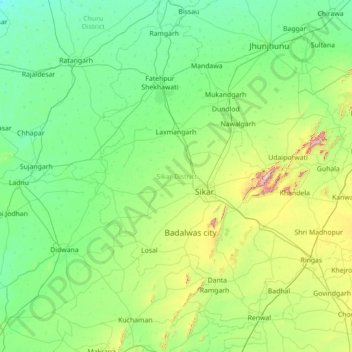
Name: Sikar topographic map, elevation, terrain.
Location: Sikar, Rajasthan, India (27.12106 74.68125 28.20386 75.74445)
Average elevation: 387 m
Minimum elevation: 289 m
Maximum elevation: 1,032 m
Make a donation
Gear up for your next adventure:
As an Amazon Associate, this site earns from qualifying purchases at no extra cost to you.
Other topographic maps
Click on a map to view its topography, its elevation and its terrain.
Udaipur
India > Rajasthan > Girwa Tehsil
Udaipur is located at 24°31′30″N 73°40′38″E / 24.525049°N 73.677116°E / 24.525049; 73.677116. The city covers an area of 64 km2 (25 sq mi) and lies at an altitude of 598.00 m (1,962 ft) above sea level. It is located in the southern region of Rajasthan, near the Gujarat border. The city…
Average elevation: 656 m
Make a donation
Gear up for your next adventure:
As an Amazon Associate, this site earns from qualifying purchases at no extra cost to you.
Sojat
India > Rajasthan > Sojat Tehsil
Sojat is located at 25°55′N 73°40′E / 25.92°N 73.67°E / 25.92; 73.67. It has an average elevation of 257 metres (843 feet). The whole region lies on the way of "Aravali hills range" which is the oldest hill range in India.
Average elevation: 270 m
Make a donation
Gear up for your next adventure:
As an Amazon Associate, this site earns from qualifying purchases at no extra cost to you.
Make a donation
Gear up for your next adventure:
As an Amazon Associate, this site earns from qualifying purchases at no extra cost to you.
Make a donation
Gear up for your next adventure:
As an Amazon Associate, this site earns from qualifying purchases at no extra cost to you.
Deeg
India > Rajasthan > Deeg Tehsil
Deeg is located at 27°28′N 77°20′E / 27.47°N 77.33°E / 27.47; 77.33. It has an average elevation of 174 m (571 ft).
Average elevation: 183 m
Make a donation
Gear up for your next adventure:
As an Amazon Associate, this site earns from qualifying purchases at no extra cost to you.
Sagwara
India > Rajasthan > Sagwara Tehsil
Sagwara is located in the east-central Dungarpur district, in Sagwara Tehsil. It has an average elevation of 244 metres (801 ft). Sagwara is famous for its sculpture, marble carving, temple architecture and gold jewelry. It is a major trading hub for nearby villages.
Average elevation: 177 m
Make a donation
Gear up for your next adventure:
As an Amazon Associate, this site earns from qualifying purchases at no extra cost to you.
Make a donation
Gear up for your next adventure:
As an Amazon Associate, this site earns from qualifying purchases at no extra cost to you.
Bikaner
India > Rajasthan > Bikaner Tehsil
Around a century after Rao Bika founded Bikaner, the state's fortunes flourished under the sixth Raja, Rai Singhji, who ruled from 1571 to 1611. During the Mughal Empire's rule in the country, Raja Rai Singh accepted the suzerainty of the Mughals and held a high rank as an army general at the court of the…
Average elevation: 225 m
Make a donation
Gear up for your next adventure:
As an Amazon Associate, this site earns from qualifying purchases at no extra cost to you.
Make a donation
Gear up for your next adventure:
As an Amazon Associate, this site earns from qualifying purchases at no extra cost to you.
Haldighati Park
India > Rajasthan > Sanganer Tehsil > Jaipur Municipal Corporation
Average elevation: 372 m
Make a donation
Gear up for your next adventure:
As an Amazon Associate, this site earns from qualifying purchases at no extra cost to you.
Baran
India > Rajasthan > Baran Tehsil
Baran is located at 25°06′N 76°31′E / 25.1°N 76.52°E / 25.1; 76.52. It has an average elevation of 262 metres (859 ft). It is surrounded by three Rivers Kalisindh, Parvati and Parban. The city is situated on the border of Rajasthan and Madhya Pradesh.
Average elevation: 264 m
Make a donation
Gear up for your next adventure:
As an Amazon Associate, this site earns from qualifying purchases at no extra cost to you.
Make a donation
Gear up for your next adventure:
As an Amazon Associate, this site earns from qualifying purchases at no extra cost to you.
Make a donation
Gear up for your next adventure:
As an Amazon Associate, this site earns from qualifying purchases at no extra cost to you.
Pratapgarh
India > Rajasthan > Pratapgarh Tehsil
Pratapgarh District is a newly constituted district in Rajasthan state. it came into existence on 26 January 2008, as the 33rd district of Rajasthan. Pratapgarh is located at 24.03° N 74.78° E. It has an average elevation of 491 metres (1610 feet). It is said to be the second highest place in Rajasthan after…
Average elevation: 503 m
Nathdwara
India > Rajasthan > Nathdwara Tehsil
Nathdwara is located at 24°56′N 73°49′E / 24.93°N 73.82°E / 24.93; 73.82. It has an average elevation of 584 metres (1919 ft). Located just 48 km north-east of Udaipur in Rajasthan, this town is easily reached by air, road or nearest rail-head.
Average elevation: 590 m
Make a donation
Gear up for your next adventure:
As an Amazon Associate, this site earns from qualifying purchases at no extra cost to you.
Make a donation
Gear up for your next adventure:
As an Amazon Associate, this site earns from qualifying purchases at no extra cost to you.
Khetri
India > Rajasthan > Khetri Tehsil
Khetri is located at 27°59′N 75°48′E / 27.98°N 75.8°E / 27.98; 75.8. It has an average elevation of 484 metres (1587 feet). The name of the mountain in Khetri is Bhopalgarh.
Average elevation: 452 m
Make a donation
Gear up for your next adventure:
As an Amazon Associate, this site earns from qualifying purchases at no extra cost to you.
Balotra
India > Rajasthan > Pachpadra Tehsil
Balotra is located at 25°50′N 72°14′E / 25.83°N 72.23°E / 25.83; 72.23. It has an average elevation of 106 metres (347 feet).
Average elevation: 124 m
Make a donation
Gear up for your next adventure:
As an Amazon Associate, this site earns from qualifying purchases at no extra cost to you.
Make a donation
Gear up for your next adventure:
As an Amazon Associate, this site earns from qualifying purchases at no extra cost to you.
Kumbhalgarh Fort
India > Rajasthan > Kumbhalgarh Tehsil > Quila Kumbhalgarh > Aret
Average elevation: 876 m
Make a donation
Gear up for your next adventure:
As an Amazon Associate, this site earns from qualifying purchases at no extra cost to you.
Make a donation
Gear up for your next adventure:
As an Amazon Associate, this site earns from qualifying purchases at no extra cost to you.
Make a donation
Gear up for your next adventure:
As an Amazon Associate, this site earns from qualifying purchases at no extra cost to you.
Make a donation
Gear up for your next adventure:
As an Amazon Associate, this site earns from qualifying purchases at no extra cost to you.
Make a donation
Gear up for your next adventure:
As an Amazon Associate, this site earns from qualifying purchases at no extra cost to you.
Make a donation
Gear up for your next adventure:
As an Amazon Associate, this site earns from qualifying purchases at no extra cost to you.
Make a donation
Gear up for your next adventure:
As an Amazon Associate, this site earns from qualifying purchases at no extra cost to you.