
Sassafras Mountain topographic map
Interactive map
Click on the map to display elevation.
Sassafras Mountain
The Pisgah Quadrangle topographical map, revised 1904–1905, shows the long abandoned Sassafras Gap Road to be the preferred route through to Rosman, N.C. and Brevard, N.C. at the end of the 19th Century and that the existing Highway 178 was then a secondary road. This abandoned road is a short distance from the summit and is crossed by the hiking trail to Caesars Head from Sassafras summit. Most people crossing this old roadbed in Sassafras Gap don't recognize it as a road, but it is easily recognized because of the short section of steps going down into the roadbed, and a similar section of short steps on the opposite side of the roadbed going up and the trail then continuing steeply up toward Caesars Head. A short hike South down the old Sassafras Gap Road will take you to Hickory Head Spring, the headwater of the South Saluda River. Hickory Head Spring is shown as a feature on the Mill's Atlas, 1825, Greenville District, South Carolina.
About this map
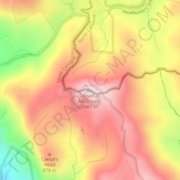
Name: Sassafras Mountain topographic map, elevation, terrain.
Average elevation: 895 m
Minimum elevation: 624 m
Maximum elevation: 1,071 m
Other topographic maps
Click on a map to view its topography, its elevation and its terrain.
Charleston
United States > South Carolina > Charleston County
Charleston is characterized by its relatively flat topography, with an average elevation of about 10 feet above sea level, making it prone to flooding during heavy rains and storms. The city is situated on a peninsula bordered by the Ashley River to the west and the Cooper River to the east, creating a natural…
Average elevation: 4 m
Greenville
United States > South Carolina > Greenville County
Greenville features a varied topography characterized by rolling hills and the nearby Blue Ridge Mountains. The city sits at an elevation of approximately 984 feet (300 meters) above sea level, with its landscape shaped significantly by the Reedy River, which flows through the heart of downtown, creating…
Average elevation: 290 m
Columbia
United States > South Carolina > Richland County
Columbia features a relatively gentle and rolling topography. The elevation in this area varies, with the city itself situated around 318 feet above sea level, while the surrounding regions exhibit elevations that can reach as high as 573 feet. The landscape is characterized by a mix of low-lying areas and…
Average elevation: 89 m
Lexington County
United States > South Carolina
Lexington County is characterized by a diverse topography that includes gently rolling hills and numerous waterways. The county's elevation averages around 400 feet, with variations across its 757.62 square miles, comprising both urban and rural landscapes. A significant feature of the area is Lake Murray,…
Average elevation: 116 m
Horry County
United States > South Carolina
Horry County features a diverse topography that ranges from coastal plains to elevated inland areas. The county's eastern boundary runs along the Atlantic Ocean, characterized by sandy beaches and a series of coastal barriers, which transition into marshy wetlands. Moving inland, the terrain gradually rises to…
Average elevation: 14 m
Myrtle Beach
United States > South Carolina > Horry County
Myrtle Beach features a predominantly flat topography characterized by its coastal plain setting. The area is situated just a few feet above sea level, with an average elevation of approximately 20 feet (6 meters), making it ideal for expansive sandy beaches and shallow tidal estuaries. The region is part of a…
Average elevation: 6 m
Florence
United States > South Carolina > Florence County
Florence is located in the coastal plain of South Carolina. It is in the northeastern part of the state and the northern part of Florence County. The average elevation above sea level is around 140 ft (43 m). Jeffries Creek is a tributary of the Great Pee Dee River and is the main waterway that flows through…
Average elevation: 37 m
Rock Hill
United States > South Carolina > York County
Rock Hill is located along the Catawba River in the north-central section of the Piedmont of South Carolina, south of the city of Charlotte in North Carolina. The city sits at an elevation of around 676 feet (206 m) above sea level. It is located approximately 150 miles (240 km) from the Atlantic Ocean and 75…
Average elevation: 184 m
Pickens County
United States > South Carolina
According to the U.S. Census Bureau, the county has a total area of 512 square miles (1,330 km2), of which 496 square miles (1,280 km2) is land and 16 square miles (41 km2) (3.1%) is water. The county also contains the highest natural point in South Carolina, Sassafras Mountain, with an elevation of 3560 feet…
Average elevation: 326 m
Kiawah Island
United States > South Carolina > Charleston County
Kiawah Island features a low-lying, sandy topography typical of barrier islands along the southeastern coast of the United States. The island's average elevation is about 10 feet above sea level, with some areas reaching slightly higher. Its terrain is characterized by broad, flat beaches that gently slope…
Average elevation: 2 m
Simpsonville
United States > South Carolina > Greenville County
Simpsonville is located in southeastern Greenville County at 34°44′0″N 82°15′36″W / 34.73333°N 82.26000°W / 34.73333; -82.26000 (34.733375, -82.260001), between Mauldin to the northwest and Fountain Inn to the southeast. The center of town has an elevation of 866 feet (264 m) above sea level.
Average elevation: 258 m
Dawson Park
United States > South Carolina > Pickens County > Clemson > Briarwood
Average elevation: 233 m
Hardeeville
United States > South Carolina > Jasper County
The city is located on the Atlantic coastal plain, with very few variations in elevation. The average elevation of the city is approximately 20 feet (6.1 m) above mean sea level. Most of Hardeeville is located within Jasper County, though a small portion of the city crosses into Beaufort County. Much of the…
Average elevation: 5 m
Lake Wylie
United States > South Carolina > York County
Lake Wylie is located on a peninsula along the shore of Lake Wylie in the Piedmont of both North and South Carolina, at 35°6′22″N 81°3′25″W / 35.10611°N 81.05694°W / 35.10611; -81.05694 (35.105973, -81.056978). According to the United States Census Bureau, the CDP has a total area of 4.7…
Average elevation: 188 m