
Make a donation
Gear up for your next adventure:
As an Amazon Associate, this site earns from qualifying purchases at no extra cost to you.
Lubań topographic map
Click on the map to display elevation.
Make a donation
Gear up for your next adventure:
As an Amazon Associate, this site earns from qualifying purchases at no extra cost to you.
About this map
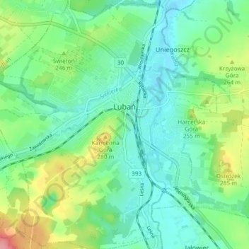
Name: Lubań topographic map, elevation, terrain.
Average elevation: 237 m
Minimum elevation: 206 m
Maximum elevation: 313 m
Make a donation
Gear up for your next adventure:
As an Amazon Associate, this site earns from qualifying purchases at no extra cost to you.
Other topographic maps
Click on a map to view its topography, its elevation and its terrain.
Góry Kaczawskie
Poland > Lower Silesian Voivodeship > Złotoryja County > Wojcieszów
Average elevation: 526 m
Szubianka
Poland > Lower Silesian Voivodeship > Kamienna Góra County > Kamienna Góra
Average elevation: 468 m
Make a donation
Gear up for your next adventure:
As an Amazon Associate, this site earns from qualifying purchases at no extra cost to you.
Góry Sowie
Poland > Lower Silesian Voivodeship > Wałbrzych County > Rzeczka
Seen from the Silesian Lowlands in the northeast, the Owl Mountains form a comparatively steep edge of the Central Sudetes, though the range is very diversified in terms of height. The highest peaks are Wielka Sowa ("Great Owl", at 1,014 m (3,327 ft) in altitude) and Kalenica (964 m (3,163 ft)) with their…
Average elevation: 831 m
Kopciowa
Poland > Lower Silesian Voivodeship > Ząbkowice Śląskie County > Chwalisław
Average elevation: 591 m
Śnieżka / Sněžka
Poland > Lower Silesian Voivodeship > Karkonosze County > Karpacz
Due to high altitude the climate is maritime polar (Köppen: ET) not far from a continental subpolar climate (Dfc). The difference should be at least 6 °C lower on annual average compared to the weather station in the plains.
Average elevation: 1,263 m
Kowadło/Kovadlina
Poland > Lower Silesian Voivodeship > Kłodzko County > Bielice
Average elevation: 793 m
Make a donation
Gear up for your next adventure:
As an Amazon Associate, this site earns from qualifying purchases at no extra cost to you.
Sokolik Duży
Poland > Lower Silesian Voivodeship > Karkonosze County > Bobrów
Average elevation: 431 m
Wojcieszyce Dolne
Poland > Lower Silesian Voivodeship > Karkonosze County > Wojcieszyce
Average elevation: 407 m
Węglówka
Poland > Lower Silesian Voivodeship > Ząbkowice Śląskie County > Opolnica
Average elevation: 391 m
Make a donation
Gear up for your next adventure:
As an Amazon Associate, this site earns from qualifying purchases at no extra cost to you.
Make a donation
Gear up for your next adventure:
As an Amazon Associate, this site earns from qualifying purchases at no extra cost to you.
Zamek Grodziec
Poland > Lower Silesian Voivodeship > Złotoryja County > Grodziec
Average elevation: 269 m
Śnieżka / Sněžka
Poland > Lower Silesian Voivodeship > Karkonosze County > Karpacz
Due to high altitude the climate is maritime polar (Köppen: ET) not far from a continental subpolar climate (Dfc). The difference should be at least 6 °C lower on annual average compared to the weather station in the plains.
Average elevation: 1,262 m
Make a donation
Gear up for your next adventure:
As an Amazon Associate, this site earns from qualifying purchases at no extra cost to you.
Make a donation
Gear up for your next adventure:
As an Amazon Associate, this site earns from qualifying purchases at no extra cost to you.
Bystrzyca Kłodzka
Poland > Lower Silesian Voivodeship > Kłodzko County > Bystrzyca Kłodzka > Bystrzyca Kłodzka
Average elevation: 404 m
Karkonosze
Poland > Lower Silesian Voivodeship > Jelenia Góra
The Giant Mountains, Krkonoše, or Karkonosze (Czech: [ˈkr̩konoʃɛ] , Polish pronunciation: [karkɔˈnɔʂɛ] , German: Riesengebirge pronounced [ˈʁiːzn̩ɡəˌbɪʁɡə] ), are a mountain range located in the north of the Czech Republic and the south-west of Poland, part of the Sudetes mountain system…
Average elevation: 1,196 m