
Make a donation
Gear up for your next adventure:
As an Amazon Associate, this site earns from qualifying purchases at no extra cost to you.
Auchencorth Moss topographic map
Click on the map to display elevation.
Make a donation
Gear up for your next adventure:
As an Amazon Associate, this site earns from qualifying purchases at no extra cost to you.
About this map
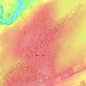
Name: Auchencorth Moss topographic map, elevation, terrain.
Average elevation: 281 m
Minimum elevation: 216 m
Maximum elevation: 300 m
Scotland trails, hiking, mountain biking, running and outdoor activities
Make a donation
Gear up for your next adventure:
As an Amazon Associate, this site earns from qualifying purchases at no extra cost to you.
Other topographic maps
Click on a map to view its topography, its elevation and its terrain.
City of Edinburgh
Edinburgh has been popularly called the Athens of the North since the early 19th century. References to Athens, such as Athens of Britain and Modern Athens, had been made as early as the 1760s. The similarities were seen to be topographical but also intellectual. Edinburgh's Castle Rock reminded returning…
Average elevation: 118 m
Shetland
Walter Scott's 1822 novel The Pirate is set in "a remote part of Shetland", and was inspired by his 1814 visit to the islands. The name Jarlshof meaning "Earl's Mansion" is a coinage of his. Robert Cowie, a doctor born in Lerwick published the 1874 work.Shetland: Descriptive and Historical; Being a Graduation…
Average elevation: 4 m
Make a donation
Gear up for your next adventure:
As an Amazon Associate, this site earns from qualifying purchases at no extra cost to you.
Aberdeen City
Two weather stations collect climate data for the area, Aberdeen/Dyce Airport, and Craibstone. Both are about 4+1⁄2 miles (7 km) to the north west of the city centre, and given that they are in close proximity to each other, exhibit very similar climatic regimes. Dyce tends to have marginally warmer daytime…
Average elevation: 46 m
Skye
United Kingdom > Scotland > Highland
Beyond Loch Snizort to the west of Trotternish is the Waternish peninsula, which ends in Ardmore Point's double rock arch. Duirinish peninsula is separated from Waternish by Loch Dunvegan, which contains the island of Isay. It is ringed by sea cliffs that reach 296 metres (971 feet) on the west at Waterstein…
Average elevation: 63 m
Make a donation
Gear up for your next adventure:
As an Amazon Associate, this site earns from qualifying purchases at no extra cost to you.
Isle of Arran
United Kingdom > Scotland > North Ayrshire
The island has three endemic species of tree, the Arran whitebeams. These trees are the Scottish or Arran whitebeam (Sorbus arranensis), the bastard mountain ash or cut-leaved whitebeam (Sorbus pseudofennica) and the Catacol whitebeam (Sorbus pseudomeinichii). If rarity is measured by numbers alone they are…
Average elevation: 98 m
Make a donation
Gear up for your next adventure:
As an Amazon Associate, this site earns from qualifying purchases at no extra cost to you.
Shetland
Walter Scott's 1822 novel The Pirate is set in "a remote part of Shetland", and was inspired by his 1814 visit to the islands. The name Jarlshof meaning "Earl's Mansion" is a coinage of his. Robert Cowie, a doctor born in Lerwick published the 1874 work entitled Shetland: Descriptive and Historical; Being a…
Average elevation: 4 m
Make a donation
Gear up for your next adventure:
As an Amazon Associate, this site earns from qualifying purchases at no extra cost to you.
Make a donation
Gear up for your next adventure:
As an Amazon Associate, this site earns from qualifying purchases at no extra cost to you.
Make a donation
Gear up for your next adventure:
As an Amazon Associate, this site earns from qualifying purchases at no extra cost to you.
Make a donation
Gear up for your next adventure:
As an Amazon Associate, this site earns from qualifying purchases at no extra cost to you.
Orkney Islands
The southern group of islands surrounds Scapa Flow. Hoy, to the west, is the second largest of the Orkney Isles and Ward Hill at its northern end is the highest elevation in the archipelago. The Old Man of Hoy is a well-known seastack. Graemsay and Flotta are both linked by ferry to the Mainland and Hoy, and…
Average elevation: 7 m
Make a donation
Gear up for your next adventure:
As an Amazon Associate, this site earns from qualifying purchases at no extra cost to you.
Invergarry Castle
United Kingdom > Scotland > Highland > Invergarry
The survey drawing shows a plan and elevations of the castle, called the 'Castle of Glangary' on the drawing. The drawing may appear misleading, as more than one facade is joined together, but by cross-referencing the lettering on the plan to the elevations the appearance can be judged.
Average elevation: 150 m
Make a donation
Gear up for your next adventure:
As an Amazon Associate, this site earns from qualifying purchases at no extra cost to you.
Dupplin Castle
United Kingdom > Scotland > Perth and Kinross > Forteviot > Aberdalgie
Average elevation: 74 m
Make a donation
Gear up for your next adventure:
As an Amazon Associate, this site earns from qualifying purchases at no extra cost to you.
Make a donation
Gear up for your next adventure:
As an Amazon Associate, this site earns from qualifying purchases at no extra cost to you.
Make a donation
Gear up for your next adventure:
As an Amazon Associate, this site earns from qualifying purchases at no extra cost to you.
Make a donation
Gear up for your next adventure:
As an Amazon Associate, this site earns from qualifying purchases at no extra cost to you.
Make a donation
Gear up for your next adventure:
As an Amazon Associate, this site earns from qualifying purchases at no extra cost to you.
Make a donation
Gear up for your next adventure:
As an Amazon Associate, this site earns from qualifying purchases at no extra cost to you.
Hirsel Lake
United Kingdom > Scotland > Scottish Borders > Coldstream > The Hirsel
Average elevation: 37 m
Make a donation
Gear up for your next adventure:
As an Amazon Associate, this site earns from qualifying purchases at no extra cost to you.
Orkney Islands
The southern group of islands surrounds Scapa Flow. Hoy, to the west, is the second largest of the Orkney Isles and Ward Hill at its northern end is the highest elevation in the archipelago. The Old Man of Hoy is a well-known seastack. Graemsay and Flotta are both linked by ferry to the Mainland and Hoy, and…
Average elevation: 7 m
Make a donation
Gear up for your next adventure:
As an Amazon Associate, this site earns from qualifying purchases at no extra cost to you.
Make a donation
Gear up for your next adventure:
As an Amazon Associate, this site earns from qualifying purchases at no extra cost to you.
Falkirk
United Kingdom > Scotland > Falkirk
Falkirk is located in an area of undulating topography between the Slamannan Plateau and the upper reaches of the Firth of Forth. The area to the north of Falkirk is part of the floodplain of the River Carron. Two tributaries of the River Carron - the East Burn and the West Burn flow through the town and form…
Average elevation: 42 m
Make a donation
Gear up for your next adventure:
As an Amazon Associate, this site earns from qualifying purchases at no extra cost to you.
Loch Errochty
United Kingdom > Scotland > Perth and Kinross
Loch Errochty is a man made freshwater loch situated within the Perth and Kinross council area at the edge of the Scottish Highlands near the Highland Boundary Fault where the topography changes to lowland.
Average elevation: 457 m
Make a donation
Gear up for your next adventure:
As an Amazon Associate, this site earns from qualifying purchases at no extra cost to you.
Castle Stalker
United Kingdom > Scotland > Argyll and Bute > Appin > Achosrigan
Average elevation: 32 m
Make a donation
Gear up for your next adventure:
As an Amazon Associate, this site earns from qualifying purchases at no extra cost to you.
Aberdeen City
Two weather stations collect climate data for the area, Aberdeen/Dyce Airport, and Craibstone. Both are about 4+1⁄2 miles (7 km) to the northwest of the city centre, and given that they are in close proximity to each other, exhibit very similar climatic regimes. Dyce tends to have marginally warmer daytime…
Average elevation: 46 m
Make a donation
Gear up for your next adventure:
As an Amazon Associate, this site earns from qualifying purchases at no extra cost to you.
Make a donation
Gear up for your next adventure:
As an Amazon Associate, this site earns from qualifying purchases at no extra cost to you.
Orkney Islands
The southern group of islands surrounds Scapa Flow. Hoy, to the west, is the second largest of the Orkney Isles and Ward Hill at its northern end is the highest elevation in the archipelago. The Old Man of Hoy is a well-known seastack. Graemsay and Flotta are both linked by ferry to the Mainland and Hoy, and…
Average elevation: 7 m
Make a donation
Gear up for your next adventure:
As an Amazon Associate, this site earns from qualifying purchases at no extra cost to you.
Make a donation
Gear up for your next adventure:
As an Amazon Associate, this site earns from qualifying purchases at no extra cost to you.