
Sgùrr na Stri topographic map
Interactive map
Click on the map to display elevation.
About this map
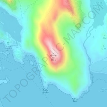
Name: Sgùrr na Stri topographic map, elevation, terrain.
Location: Sgùrr na Stri, Highland, Scotland, United Kingdom (57.19610 -6.14074 57.19620 -6.14064)
Average elevation: 92 m
Minimum elevation: 0 m
Maximum elevation: 491 m
Scotland trails, hiking, mountain biking, running and outdoor activities
Other topographic maps
Click on a map to view its topography, its elevation and its terrain.
Orkney Islands
The southern group of islands surrounds Scapa Flow. Hoy, to the west, is the second largest of the Orkney Isles and Ward Hill at its northern end is the highest elevation in the archipelago. The Old Man of Hoy is a well-known seastack. Graemsay and Flotta are both linked by ferry to the Mainland and Hoy, and…
Average elevation: 7 m
Skye
United Kingdom > Scotland > Highland
Beyond Loch Snizort to the west of Trotternish is the Waternish peninsula, which ends in Ardmore Point's double rock arch. Duirinish peninsula is separated from Waternish by Loch Dunvegan, which contains the island of Isay. It is ringed by sea cliffs that reach 296 metres (971 feet) on the west at Waterstein…
Average elevation: 63 m
North Rona
United Kingdom > Scotland > Western Isles
Rona (Scottish Gaelic: Rònaigh) is an uninhabited Scottish island in the North Atlantic. It is often referred to as North Rona to distinguish it from the island of South Rona in the Inner Hebrides. It has an area of 109 hectares (270 acres) and a maximum elevation of 108 metres (354 ft).
Average elevation: 4 m
City of Edinburgh
Edinburgh has been popularly called the Athens of the North since the early 19th century. References to Athens, such as Athens of Britain and Modern Athens, had been made as early as the 1760s. The similarities were seen to be topographical but also intellectual. Edinburgh's Castle Rock reminded returning…
Average elevation: 118 m
Isle of Arran
United Kingdom > Scotland > North Ayrshire
The island has three endemic species of tree, the Arran whitebeams. These trees are the Scottish or Arran whitebeam (Sorbus arranensis), the bastard mountain ash or cut-leaved whitebeam (Sorbus pseudofennica) and the Catacol whitebeam (Sorbus pseudomeinichii). If rarity is measured by numbers alone they are…
Average elevation: 98 m
Shetland
Walter Scott's 1822 novel The Pirate is set in "a remote part of Shetland", and was inspired by his 1814 visit to the islands. The name Jarlshof meaning "Earl's Mansion" is a coinage of his. Robert Cowie, a doctor born in Lerwick published the 1874 work.Shetland: Descriptive and Historical; Being a Graduation…
Average elevation: 4 m
Skye
United Kingdom > Scotland > Highland
Beyond Loch Snizort to the west of Trotternish is the Waternish peninsula, which ends in Ardmore Point's double rock arch. Duirinish peninsula is separated from Waternish by Loch Dunvegan, which contains the island of Isay. It is ringed by sea cliffs that reach 296 metres (971 feet) on the west at Waterstein…
Average elevation: 63 m
Aberdeen City
Two weather stations collect climate data for the area, Aberdeen/Dyce Airport, and Craibstone. Both are about 4+1⁄2 miles (7 km) to the north west of the city centre, and given that they are in close proximity to each other, exhibit very similar climatic regimes. Dyce tends to have marginally warmer daytime…
Average elevation: 46 m
Orkney Islands
The southern group of islands surrounds Scapa Flow. Hoy, to the west, is the second largest of the Orkney Isles and Ward Hill at its northern end is the highest elevation in the archipelago. The Old Man of Hoy is a well-known seastack. Graemsay and Flotta are both linked by ferry to the Mainland and Hoy, and…
Average elevation: 7 m
Low Banks
United Kingdom > Scotland > South Lanarkshire > Lamington > Millhill
Average elevation: 263 m
Aberdeen City
Two weather stations collect climate data for the area, Aberdeen/Dyce Airport, and Craibstone. Both are about 4+1⁄2 miles (7 km) to the northwest of the city centre, and given that they are in close proximity to each other, exhibit very similar climatic regimes. Dyce tends to have marginally warmer daytime…
Average elevation: 46 m
East Ayrshire
East Ayrshire is located on the west coat of Scotland, sharing borders with the following neighbouring council areas; North Ayrshire, South Ayrshire, Dumfries and Galloway, East Renfrewshire and South Lanarkshire. Blackcraig Hill reaches an elevation of 2,298 feet (700 metres), the highest peak in East…
Average elevation: 225 m
Aberdeen City
Two weather stations collect climate data for the area, Aberdeen/Dyce Airport, and Craibstone. Both are about 4+1⁄2 miles (7 km) to the northwest of the city centre, and given that they are in close proximity to each other, exhibit very similar climatic regimes. Dyce tends to have marginally warmer daytime…
Average elevation: 46 m
Ardnamurchan
United Kingdom > Scotland > Highland
The north western corner of Ardnamurchan consists of a lopolith (previously interpreted as a ring dyke) that has been exposed at the surface. Evidence for such a structure can be identified from the phenocrysts in the rock exposures around the area of interest which show plagioclase crystals aligned towards…
Average elevation: 73 m
Caithness
Caithness extends about 30 miles (48 km) north-south and about 30 miles (48 km) east-west, with a roughly triangular-shaped area of about 712 sq mi (1,840 km2). The topography is generally flat, in contrast to the majority of the remainder of the North of Scotland. Until the latter part of the 20th century…
Average elevation: 79 m
Benbecula
United Kingdom > Scotland > Western Isles > Nunton
There is a dense cluster of lochs across almost the entire island, and almost the whole island is below 20 metres (70 feet) in elevation.
Average elevation: 5 m
City of Edinburgh
Edinburgh has been popularly called the Athens of the North since the early 19th century. References to Athens, such as Athens of Britain and Modern Athens, had been made as early as the 1760s. The similarities were seen to be topographical but also intellectual. Edinburgh's Castle Rock reminded returning…
Average elevation: 118 m
Aberdeen City
Two weather stations collect climate data for the area, Aberdeen/Dyce Airport, and Craibstone. Both are about 4+1⁄2 miles (7 km) to the northwest of the city centre, and given that they are in close proximity to each other, exhibit very similar climatic regimes. Dyce tends to have marginally warmer daytime…
Average elevation: 46 m