
River Clyde topographic map
Interactive map
Click on the map to display elevation.
About this map
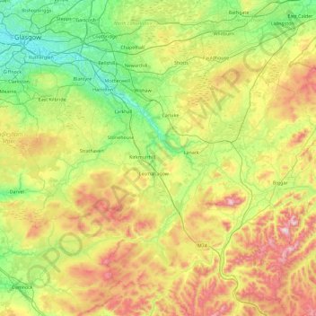
Name: River Clyde topographic map, elevation, terrain.
Location: River Clyde, South Lanarkshire, Scotland, United Kingdom (55.40684 -4.46261 55.92070 -3.55833)
Average elevation: 245 m
Minimum elevation: 1 m
Maximum elevation: 727 m
South Lanarkshire trails, hiking, mountain biking, running and outdoor activities
Other topographic maps
Click on a map to view its topography, its elevation and its terrain.
Drumclog
United Kingdom > Scotland > South Lanarkshire
Drumclog is a small village in South Lanarkshire, Parish of Avendale and Drumclog, Scotland. The settlement is situated on the A71, between Caldermill and Priestland in East Ayrshire at an elevation of 197 metres (646 feet) and about five miles (eight kilometres) west of Strathaven.
Average elevation: 216 m
Low Banks
United Kingdom > Scotland > South Lanarkshire > Lamington > Millhill
Average elevation: 263 m
Langlands Moss Local Nature Reserve
United Kingdom > Scotland > South Lanarkshire > East Kilbride
Average elevation: 204 m
Rigside
United Kingdom > Scotland > South Lanarkshire
Drumalbin is a Met Office weather station near Rigside, situated at an elevation of 245 m.
Average elevation: 244 m
Craignethan Castle
United Kingdom > Scotland > South Lanarkshire > Crossford > Tillietudlem
Average elevation: 121 m
Clyde Valley Family Park's Island
United Kingdom > Scotland > South Lanarkshire > Hazelbank > Birkhill
Average elevation: 119 m
Langlands Moss Lowland Raised Peatbog
United Kingdom > Scotland > South Lanarkshire > East Kilbride
Average elevation: 204 m
East Kilbride
United Kingdom > Scotland > South Lanarkshire
The earliest-known evidence of occupation in the area dates as far back as the late Neolithic and Early Bronze Age, as archaeological investigation has demonstrated that burial cairns in the district began as ceremonial or ritual sites of burial during the Neolithic, with the use of cup-marked, and other…
Average elevation: 174 m
Tinto Hill
United Kingdom > Scotland > South Lanarkshire
At the summit sits "Tinto Cairn", and with a diameter of 45 m (148 ft) and a height of 6 m (20 ft) it is one of the largest Bronze Age round cairns in Scotland, most of which are found at lower elevations.
Average elevation: 436 m
East Kilbride
United Kingdom > Scotland > South Lanarkshire
The earliest-known evidence of occupation in the area dates as far back as the late Neolithic and Early Bronze Age, as archaeological investigation has demonstrated that burial cairns in the district began as ceremonial or ritual sites of burial during the Neolithic, with the use of cup-marked, and other…
Average elevation: 174 m
Avon Gorge
United Kingdom > Scotland > South Lanarkshire > Larkhall > Morgan Glen
Average elevation: 118 m
Trough Linn Woodlands Project
United Kingdom > Scotland > South Lanarkshire > East Kilbride
Average elevation: 185 m