
Make a donation
Gear up for your next adventure:
As an Amazon Associate, this site earns from qualifying purchases at no extra cost to you.
East Sussex topographic map
Click on the map to display elevation.
Make a donation
Gear up for your next adventure:
As an Amazon Associate, this site earns from qualifying purchases at no extra cost to you.
East Sussex
The chalk uplands of the South Downs occupies the coastal strip between Brighton and Eastbourne. There are two river gaps: the Rivers Ouse and Cuckmere. The Seven Sisters, where the Downs meet the sea, are the remnants of dry valleys cut into the chalk; they end at Beachy Head, 530 feet (162 m) above sea level. To the east of Beachy Head lie the marshlands of the Pevensey Levels, formerly flooded by the sea but now enclosed within a deposited beach. At Bexhill the land begins to rise again where the sands and clays of the Weald meet the sea; these culminate in the sandstone cliffs east of Hastings. Further east are the Pett Levels, more marshland, beyond which is the estuary of the River Rother. On the far side of the estuary are the dunes of Camber Sands. The highest point in the county is Ditchling Beacon on the South Downs, which has a maximum elevation of 248 m (814 ft) and is classed as a Marilyn.
Make a donation
Gear up for your next adventure:
As an Amazon Associate, this site earns from qualifying purchases at no extra cost to you.
About this map
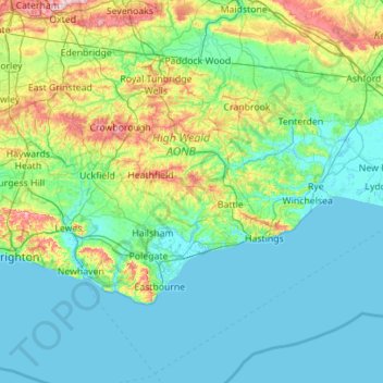
Name: East Sussex topographic map, elevation, terrain.
Location: East Sussex, England, United Kingdom (50.73343 -0.24508 51.14746 0.86786)
Average elevation: 44 m
Minimum elevation: -2 m
Maximum elevation: 270 m
East Sussex trails, hiking, mountain biking, running and outdoor activities
Make a donation
Gear up for your next adventure:
As an Amazon Associate, this site earns from qualifying purchases at no extra cost to you.
Other topographic maps
Click on a map to view its topography, its elevation and its terrain.
Make a donation
Gear up for your next adventure:
As an Amazon Associate, this site earns from qualifying purchases at no extra cost to you.
Make a donation
Gear up for your next adventure:
As an Amazon Associate, this site earns from qualifying purchases at no extra cost to you.
Make a donation
Gear up for your next adventure:
As an Amazon Associate, this site earns from qualifying purchases at no extra cost to you.
Make a donation
Gear up for your next adventure:
As an Amazon Associate, this site earns from qualifying purchases at no extra cost to you.
Battle of Hastings
United Kingdom > England > East Sussex > Rother > Catsfield
Battle Abbey was founded by William at the site of the battle. According to 12th-century sources, William made a vow to found the abbey, and the high altar of the church was placed at the site where Harold had died. More likely, the foundation was imposed on William by papal legates in 1070. The topography of…
Average elevation: 60 m
Highwoods SSSI
United Kingdom > England > East Sussex > Rother > Bexhill-on-Sea
Average elevation: 28 m
Make a donation
Gear up for your next adventure:
As an Amazon Associate, this site earns from qualifying purchases at no extra cost to you.
Make a donation
Gear up for your next adventure:
As an Amazon Associate, this site earns from qualifying purchases at no extra cost to you.
Make a donation
Gear up for your next adventure:
As an Amazon Associate, this site earns from qualifying purchases at no extra cost to you.
Make a donation
Gear up for your next adventure:
As an Amazon Associate, this site earns from qualifying purchases at no extra cost to you.
Ashdown Forest
United Kingdom > England > East Sussex > Wealden
Ashdown Forest is an ancient area of open heathland occupying the highest sandy ridge-top of the High Weald Area of Outstanding Natural Beauty. It is situated 30 miles (48 km) south of London in the county East Sussex, England. Rising to an elevation of 732 feet (223 m) above sea level, its heights provide…
Average elevation: 117 m
Make a donation
Gear up for your next adventure:
As an Amazon Associate, this site earns from qualifying purchases at no extra cost to you.
Sheffield Green
United Kingdom > England > East Sussex > Wealden > Sheffield Park
Average elevation: 50 m
Make a donation
Gear up for your next adventure:
As an Amazon Associate, this site earns from qualifying purchases at no extra cost to you.
Make a donation
Gear up for your next adventure:
As an Amazon Associate, this site earns from qualifying purchases at no extra cost to you.
Make a donation
Gear up for your next adventure:
As an Amazon Associate, this site earns from qualifying purchases at no extra cost to you.
Make a donation
Gear up for your next adventure:
As an Amazon Associate, this site earns from qualifying purchases at no extra cost to you.
Make a donation
Gear up for your next adventure:
As an Amazon Associate, this site earns from qualifying purchases at no extra cost to you.
Northbridge Street
United Kingdom > England > East Sussex > Rother > Robertsbridge
Average elevation: 40 m
Make a donation
Gear up for your next adventure:
As an Amazon Associate, this site earns from qualifying purchases at no extra cost to you.
Make a donation
Gear up for your next adventure:
As an Amazon Associate, this site earns from qualifying purchases at no extra cost to you.
Make a donation
Gear up for your next adventure:
As an Amazon Associate, this site earns from qualifying purchases at no extra cost to you.
Chuck Hatch
United Kingdom > England > East Sussex > Wealden > Upper Hartfield
Average elevation: 112 m
Make a donation
Gear up for your next adventure:
As an Amazon Associate, this site earns from qualifying purchases at no extra cost to you.
Punnetts Town Recreation Ground
United Kingdom > England > East Sussex > Wealden > Punnett's Town > Chapel Cross
Average elevation: 125 m
Make a donation
Gear up for your next adventure:
As an Amazon Associate, this site earns from qualifying purchases at no extra cost to you.
Broadwater Warren Nature Reserve
United Kingdom > England > East Sussex > Wealden > Groombridge
Average elevation: 84 m
Make a donation
Gear up for your next adventure:
As an Amazon Associate, this site earns from qualifying purchases at no extra cost to you.
Make a donation
Gear up for your next adventure:
As an Amazon Associate, this site earns from qualifying purchases at no extra cost to you.
Make a donation
Gear up for your next adventure:
As an Amazon Associate, this site earns from qualifying purchases at no extra cost to you.
Old Heathfield
United Kingdom > England > East Sussex > Wealden > Cade Street
Average elevation: 119 m
Heathfield Park
United Kingdom > England > East Sussex > Wealden > Cade Street
Average elevation: 132 m
Make a donation
Gear up for your next adventure:
As an Amazon Associate, this site earns from qualifying purchases at no extra cost to you.
Frant Lakes
United Kingdom > England > East Sussex > Wealden > Bells Yew Green
Average elevation: 110 m
Make a donation
Gear up for your next adventure:
As an Amazon Associate, this site earns from qualifying purchases at no extra cost to you.
Make a donation
Gear up for your next adventure:
As an Amazon Associate, this site earns from qualifying purchases at no extra cost to you.