
Ladakh topographic map
Interactive map
Click on the map to display elevation.
About this map
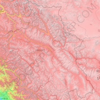
Name: Ladakh topographic map, elevation, terrain.
Location: Ladakh, India (32.33574 75.32697 35.67455 79.46075)
Average elevation: 4,726 m
Minimum elevation: 337 m
Maximum elevation: 7,470 m
The Kargil War of 1999, codenamed "Operation Vijay" by the Indian Army, saw infiltration by Pakistani troops into parts of Western Ladakh, namely Kargil, Dras, Mushkoh, Batalik and Chorbatla, overlooking key locations on the Srinagar-Leh highway. Extensive operations were launched in high altitudes by the Indian Army with considerable artillery and air force support. Pakistani troops were evicted from the Indian side of the Line of Control which the Indian government ordered was to be respected and which was not crossed by Indian troops. The Indian government was criticised by the Indian public because India respected geographical co-ordinates more than India's opponents: Pakistan and China.
Other topographic maps
Click on a map to view its topography, its elevation and its terrain.
Bengaluru
India > Karnataka > Bangalore North
Bengaluru, Bangalore North, Bengaluru Urban District, Karnataka, India
Average elevation: 881 m
Chennai
India > Tamil Nadu > Chennai
Chennai, Chennai District, Tamil Nadu, India
Average elevation: 8 m
Pune
India > Maharashtra > Pune City > Pune
Pune, Pune City, Pune District, Maharashtra, 411001, India
Average elevation: 641 m
3d
India > Rajasthan > Ganganagar Tehsil > 1 LNP
3d, 1 LNP, Ganganagar Tehsil, Sri Ganganagar District, Rajasthan, India
Average elevation: 178 m
musi
India > Telangana > Balanagar mandal > Hyderabad
musi, Greater Hyderabad Municipal Corporation North Zone, Hyderabad, Balanagar mandal, Medchal–Malkajgiri District, Telangana, India
Average elevation: 524 m
Manapparai
India > Tamil Nadu > Manapparai
Manapparai, Tiruchirappalli District, Tamil Nadu, 621306, India
Average elevation: 161 m
Tehri-Garhwal
Tehri-Garhwal, Tehri Garhwal District, Uttarakhand, 249125, India
Average elevation: 2,339 m
Kolkata
Kolkata, Kolkata District, West Bengal, 700073, India
Average elevation: 5 m
Kwatha Meitei
India > Manipur > Tengnoupal tehsil
Kwatha Meitei, Tengnoupal tehsil, Tengnoupal District, Manipur, India
Average elevation: 476 m
Western Ghats
Western Ghats, Idukki, Kerala, 685614, India
Average elevation: 2,225 m
Thiruvananthapuram
India > Kerala > Thiruvananthapuram
Thiruvananthapuram, Thiruvananthapuram District, Kerala, 695001, India
Average elevation: 33 m
Vaniyambadi
Vaniyambadi, Tirupattur District, Tamil Nadu, India
Average elevation: 559 m
Karaikudi
India > Tamil Nadu > Karaikkudi
Karaikudi, Karaikkudi, Sivagangai District, Tamil Nadu, 623001, India
Average elevation: 87 m
Mysuru
India > Karnataka > Mysuru taluk
Mysuru, Mysuru taluk, Mysuru District, Karnataka, 570001, India
Average elevation: 727 m
Rampur Bushahr
India > Himachal Pradesh > Rampur
Rampur Bushahr, Rampur, Shimla district, Himachal Pradesh, India
Average elevation: 1,715 m
Patna
India > Bihar > Patna Rural
Patna, Patna Rural, Patna District, Bihar, 800001, India
Average elevation: 51 m
Sengarai
India > Tamil Nadu > KOLLI HILLS
Sengarai, KOLLI HILLS, Namakkal District, Tamil Nadu, 637411, India
Average elevation: 1,060 m
Anaikkattu
India > Tamil Nadu > Vellore
Anaikkattu, Vellore, Vellore District, Tamil Nadu, 632101, India
Average elevation: 272 m
Gudiyatham
India > Tamil Nadu > Gudiyatham
Gudiyatham, Vellore District, Tamil Nadu, 635803, India
Average elevation: 294 m
Pernampattu
India > Tamil Nadu > Gudiyatham
Pernampattu, Gudiyatham, Vellore District, Tamil Nadu, 635810, India
Average elevation: 425 m
Arasur
India > Tamil Nadu > Thiruvennainallur
Arasur, Thiruvennainallur, Viluppuram District, Tamil Nadu, India
Average elevation: 51 m
Thandrampet
Thandrampet, Tiruvannamalai District, Tamil Nadu, India
Average elevation: 258 m
Natrampalli
India > Tamil Nadu > Tirupathur
Natrampalli, Tirupathur, Tirupattur District, Tamil Nadu, 635852, India
Average elevation: 438 m
Pandarapuram
India > Tamil Nadu > Sathankulam
Pandarapuram, Sathankulam, Thoothukudi District, Tamil Nadu, 628704, India
Average elevation: 35 m
Marungapuri
India > Tamil Nadu > Manapparai
Marungapuri, Manapparai, Tiruchirappalli District, Tamil Nadu, India
Average elevation: 249 m