
Nkuringo topographic map
Interactive map
Click on the map to display elevation.
About this map
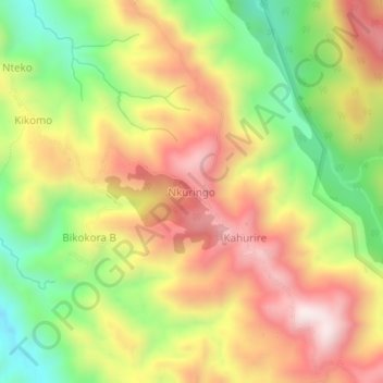
Name: Nkuringo topographic map, elevation, terrain.
Location: Nkuringo, Kisoro, Western Region, Uganda (-1.09848 29.60520 -1.05848 29.64520)
Average elevation: 1,859 m
Minimum elevation: 1,487 m
Maximum elevation: 2,215 m
Other topographic maps
Click on a map to view its topography, its elevation and its terrain.
Kisoro
Kisoro is approximately 76 kilometres (47 mi), by road, west of Kabale, the largest city in the Kigezi sub-region. This is approximately 484 kilometres (301 mi), by road, southwest of Kampala, the capital of Uganda and the country's largest city. Kisoro is east of Rumangabo and the Virunga Mountains in the…
Average elevation: 1,911 m