
Cetariu topographic map
Click on the map to display elevation.
About this map
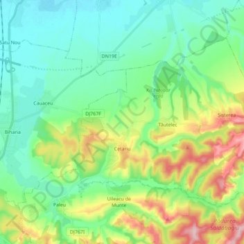
Name: Cetariu topographic map, elevation, terrain.
Location: Cetariu, Oradea Metropolitan Area, Bihor, Romania (47.11520 21.96635 47.19715 22.13936)
Average elevation: 156 m
Minimum elevation: 103 m
Maximum elevation: 285 m
Other topographic maps
Click on a map to view its topography, its elevation and its terrain.