
Oradea topographic map
Click on the map to display elevation.
About this map
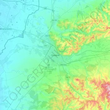
Name: Oradea topographic map, elevation, terrain.
Location: Oradea, Oradea Metropolitan Area, Bihor, 410640, Romania (46.89492 21.76852 47.21492 22.08852)
Average elevation: 155 m
Minimum elevation: 94 m
Maximum elevation: 421 m
Other topographic maps
Click on a map to view its topography, its elevation and its terrain.
Salonta
Salonta has a continental humid climate, with warm to hot summers and cold to very cold winters, but relatively little snow. The average annual precipitation is 578 mm3 (0.0353 cu in). The average January temperature is −2.4 °C (27.7 °F) and in July it is 20.7 °C (69.3 °F) (averages for low and high). It…
Average elevation: 97 m