Geolocate

Tileagd topographic map

Click on the map to display elevation.

About this map

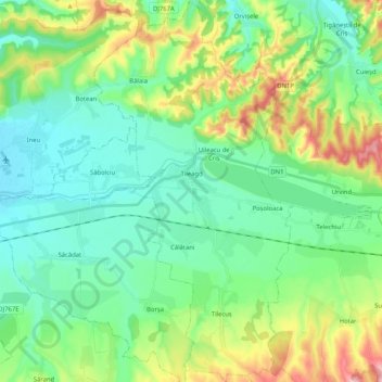
Name: Tileagd topographic map, elevation, terrain.

Location: Tileagd, Bihor, Romania (46.99704 22.14805 47.13745 22.25530)

Average elevation: 210 m

Minimum elevation: 153 m

Maximum elevation: 362 m

Other topographic maps

Click on a map to view its topography, its elevation and its terrain.

Stana de Vale

Romania > Bihor

Average elevation: 1,195 m

Ucuriș

Romania > Bihor

Average elevation: 150 m

Dobricionești

Romania > Bihor

Average elevation: 320 m

Izbucul Ponor

Romania > Bihor > Padiș

Average elevation: 1,190 m

Tomnatic

Romania > Bihor

Average elevation: 616 m

Oradea

Romania > Bihor

Average elevation: 144 m

Oradea

Romania > Bihor > Oradea

Average elevation: 155 m

Damiș

Romania > Bihor

Average elevation: 721 m

Prisaca

Romania > Bihor

Average elevation: 230 m

Remeți

Romania > Bihor

Average elevation: 674 m

Luncasprie

Romania > Bihor

Average elevation: 265 m

Apateu

Romania > Bihor

Average elevation: 177 m

Palota

Romania > Bihor

Average elevation: 113 m

Cordău

Romania > Bihor

Average elevation: 207 m

Tăutelec

Romania > Bihor

Average elevation: 178 m

Cihei

Romania > Bihor

Average elevation: 161 m

Chioag

Romania > Bihor

Average elevation: 197 m

Burzuc

Romania > Bihor

Average elevation: 208 m

Cubulcut

Romania > Bihor > Săcueni

Average elevation: 172 m

Cheresig

Romania > Bihor

Average elevation: 97 m

Chișcău

Romania > Bihor

Average elevation: 426 m

Abrămuț

Romania > Bihor

Average elevation: 133 m

Tileagd

Romania > Bihor

Average elevation: 180 m

Cordău

Romania > Bihor

Average elevation: 207 m

Vârciorog

Romania > Bihor > Vârciorog

Average elevation: 383 m

Padiș

Romania > Bihor > Padiș

Average elevation: 1,332 m

Parcul Salca

Romania > Bihor > Oradea

Average elevation: 133 m

Șuncuiuș

Romania > Bihor > Șuncuiuș

Average elevation: 409 m

Totoreni

Romania > Bihor > Totoreni

Average elevation: 217 m

Săud

Romania > Bihor > Săud

Average elevation: 296 m

Ianoșda

Romania > Bihor > Ianoșda

Average elevation: 120 m

Homorog

Romania > Bihor > Homorog

Average elevation: 103 m

Boianu Mare

Romania > Bihor > Boianu Mare

Average elevation: 222 m

Huta Voivozi

Romania > Bihor > Huta Voivozi

Average elevation: 589 m

Boiu

Romania > Bihor > Boiu

Average elevation: 94 m

Oșand

Romania > Bihor > Oșand

Average elevation: 184 m

Zece Hotare

Romania > Bihor

Average elevation: 678 m

Gear up for your next adventure:

🔦Waterproof LED Headlamps - Hands-free lighting for evening treks and emergency navigation
🧭Professional Hiking Compasses - High-precision liquid-filled compasses for map reading and orientation
👟Waterproof Leg Gaiters - Keep mud and water out of your boots in boggy terrain
🗺️Ordnance Survey Maps - Essential paper maps for hiking across the UK national parks
🧼Biodegradable Soap - Leave-no-trace hygiene for multi-day mountain treks

As an Amazon Associate, this site earns from qualifying purchases at no extra cost to you.