
Morgan County topographic map
Interactive map
Click on the map to display elevation.
About this map
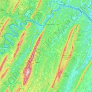
Name: Morgan County topographic map, elevation, terrain.
Location: Morgan County, West Virginia, United States (39.39289 -78.46871 39.69579 -78.02205)
Average elevation: 276 m
Minimum elevation: 114 m
Maximum elevation: 789 m
Other topographic maps
Click on a map to view its topography, its elevation and its terrain.
Morgantown
United States > West Virginia > Monongalia County
During the 1970s, the U.S. Department of Transportation built an experimental driverless personal rapid transit system in the city, citing the area's variable seasonal climate and geographic elevations as factors in testing the technology's viability. The Morgantown Personal Rapid Transit (PRT) has been in use…
Average elevation: 337 m
Philippi
United States > West Virginia > Barbour County
Throughout its history, Philippi has suffered from floods because of its proximity to the river and the relatively low elevation of most of the town. The most damaging of these came in November 1985. The town has since adopted a flood plain management plan.
Average elevation: 490 m
Charleston
United States > West Virginia > Kanawha County
Charleston has a four-season humid subtropical climate (Köppen Cfa) with continental climate (Dfa) elements. Especially in winter, Charleston's average temperatures are warmer than the rest of the state, due to the city being west of the higher elevations. Spring is the most unpredictable season, and…
Average elevation: 264 m
Spruce Knob Lake
United States > West Virginia > Randolph County
Spruce Knob Lake is a 23-acre (0.093 km2) reservoir located within the Monongahela National Forest in Randolph County, West Virginia, USA. The recreation area surrounding Spruce Knob Lake contains camping and picnicking facilities as well as a boating site. At an elevation of 3,840 feet, it is the highest lake…
Average elevation: 1,204 m
Bath (Berkeley Springs)
United States > West Virginia > Morgan County
George Washington, his family members, and several colonial elites were among the town's first landowners. The town's main north-south street was named Washington, and the main east-west street was named Fairfax. Also, four acres were set aside for "suffering humanity." The area around the springs always was…
Average elevation: 232 m
Huntington
United States > West Virginia > Cabell County
Huntington is located in western Cabell County at 38°25′9.30″N 82°26′42.55″W / 38.4192500°N 82.4451528°W / 38.4192500; -82.4451528 (38.4192496, -82.4451540). The elevation is 564 feet (172 m) above sea level.
Average elevation: 218 m
Clarksburg
United States > West Virginia > Harrison County
Clarksburg is located at the junction of U.S. 50 and U.S. 19, two miles west of the junction of U.S. 50 with Interstate 79. The city lies at an elevation of 1,007 feet at the junction of Elk Creek and the West Fork River of the Monongahela River.
Average elevation: 347 m