
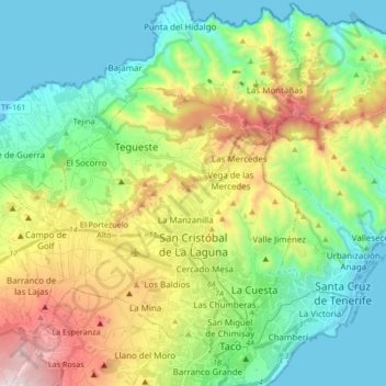
San Cristóbal de La Laguna topographic map
Interactive map
Click on the map to display elevation.
About this map
Name: San Cristóbal de La Laguna topographic map, elevation, terrain.
Average elevation: 408 m
Minimum elevation: -1 m
Maximum elevation: 1,267 m
Owing to its northerly aspect that captures moisture from the prevailing northeasterly winds, San Cristóbal de La Laguna has a Mediterranean climate (Köppen: Csb) that contrasts with the arid climate of other cities on the Canary Islands, with three to five times more rainfall than on the southern slopes, around ten percent less sunshine, and about ten percent higher humidity throughout the year. In spite of its elevation, the maritime and subtropical influences keep the temperature above frost at all times.
Other topographic maps
Click on a map to view its topography, its elevation and its terrain.
Barcelona
Spain > Catalonia > Barcelonès
Barcelona, Barcelonès, Barcelona, Catalonia, 08001, Spain
Average elevation: 65 m
Veleta
Spain > Castile and León > Valle del Retortillo
Veleta, Valle del Retortillo, Palencia, Castile and León, 34307, Spain
Average elevation: 791 m
Granada
Spain > Andalusia > Comarca de la Vega de Granada
Granada, Comarca de la Vega de Granada, Granada, Andalusia, Spain
Average elevation: 829 m
Campell
Spain > Valencian Community > Pedreguer
Campell, Pedreguer, la Marina Alta, Alacant / Alicante, Valencian Community, 03750, Spain
Average elevation: 115 m
Málaga
Spain > Andalusia > Málaga-Costa del Sol
Málaga, Málaga-Costa del Sol, Malaga, Andalusia, Spain
Average elevation: 276 m
Trillo
Trillo, Guadalajara, Castile-La Mancha, 19450, Spain
Average elevation: 899 m
Sant Martí
Spain > Catalonia > Barcelonès > Barcelona
Sant Martí, Barcelona, Barcelonès, Barcelona, Catalonia, 08001, Spain
Average elevation: 17 m
Hospital
Spain > Galicia > Os Ancares > Pedrafita do Cebreiro
Hospital, Pedrafita do Cebreiro, Os Ancares, Lugo, Galicia, Spain
Average elevation: 1,184 m
Aldeatejada
Aldeatejada, Salamanca, Castile and León, Spain
Average elevation: 838 m
Vitales
Spain > Aragon > Hoya de Huesca / Plana de Uesca > Monflorite-Lascasas
Vitales, Monflorite-Lascasas, Hoya de Huesca / Plana de Uesca, Aragon, 22112, Spain
Average elevation: 492 m
Navajas
Navajas, l'Alt Palància, Castelló / Castellón, Valencian Community, 12470, Spain
Average elevation: 441 m
la Coma
Spain > Catalonia > Solsonès > la Coma i la Pedra
la Coma, la Coma i la Pedra, Solsonès, Lleida, Catalonia, 25284, Spain
Average elevation: 1,308 m
Benifato
Benifato, la Marina Baixa, Alacant / Alicante, Valencian Community, Spain
Average elevation: 939 m
Barbadillo de Herreros
Barbadillo de Herreros, Burgos, Castile and León, 09615, Spain
Average elevation: 1,448 m
Santa Cruz de la Zarza
Santa Cruz de la Zarza, Toledo, Castile-La Mancha, 45370, Spain
Average elevation: 724 m
Blanca
Spain > Castile and León > Riello
Blanca, Riello, León, Castile and León, 24127, Spain
Average elevation: 1,193 m
Ronda
Spain > Andalusia > Serranía de Ronda
Ronda, Serranía de Ronda, Malaga, Andalusia, Spain
Average elevation: 801 m
La Unión de los Tres Ejércitos
La Unión de los Tres Ejércitos, Clavijo, Rioja, 26141, Spain
Average elevation: 650 m
Tellego
Spain > Asturias > Ribera de Arriba > Soto Ribera
Tellego, Soto Ribera, Ribera de Arriba, Asturias, 33173, Spain
Average elevation: 257 m
Alicante
Alicante, l'Alacantí, Alacant / Alicante, Valencian Community, Spain
Average elevation: 143 m
Vinaròs
Vinaròs, el Baix Maestrat, Castelló / Castellón, Valencian Community, 12500, Spain
Average elevation: 54 m
Gobernador
Spain > Andalusia > Comarca de Los Montes
Gobernador, Comarca de Los Montes, Granada, Andalusia, 18563, Spain
Average elevation: 1,090 m
Siurana
Spain > Catalonia > Upper Empordà
Siurana, Upper Empordà, Girona, Catalonia, 17469, Spain
Average elevation: 31 m
Son Servera
Spain > Balearic Islands > Llevant
Son Servera, Llevant, Balearic Islands, Spain
Average elevation: 94 m
Villar del Arzobispo
Spain > Valencian Community > La Serranía
Villar del Arzobispo, La Serranía, Valencia, Valencian Community, 46170, Spain
Average elevation: 476 m