
Make a donation
Gear up for your next adventure:
As an Amazon Associate, this site earns from qualifying purchases at no extra cost to you.
Tepi topographic map
Click on the map to display elevation.
Make a donation
Gear up for your next adventure:
As an Amazon Associate, this site earns from qualifying purchases at no extra cost to you.
Tepi
Tepi (also transliterated Teppi and Tippi) is a town in southern Ethiopia. The vowels in the name are pronounced as in the English words tape and pea. Located in the Sheka Zone of the South West Ethiopia Region, this town has a latitude and longitude of 7°12′N 35°27′E / 7.200°N 35.450°E / 7.200; 35.450 with a mean elevation of 1,097 meters above sea level. The town is said to be named after a Majangir man who once had a bee hive in the large tree that stood in the marketplace.
Make a donation
Gear up for your next adventure:
As an Amazon Associate, this site earns from qualifying purchases at no extra cost to you.
About this map
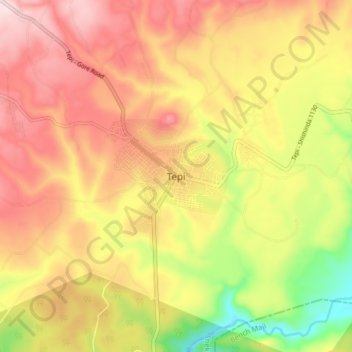
Name: Tepi topographic map, elevation, terrain.
Location: Tepi, Sheka, South West Ethiopia Peoples, Ethiopia (7.15707 35.38182 7.23707 35.46182)
Average elevation: 1,207 m
Minimum elevation: 1,007 m
Maximum elevation: 1,360 m
Make a donation
Gear up for your next adventure:
As an Amazon Associate, this site earns from qualifying purchases at no extra cost to you.
Other topographic maps
Click on a map to view its topography, its elevation and its terrain.
Bale Mountains National Park
The Bale Mountains play a vital role in climate control of the region by attracting large amounts of orographic rainfall, which has obvious implications for livestock and agricultural production. Some 600–1,000 mm (24–39 in) fall annually in the lower altitude areas, while 1,000–1,400 mm (39–55 in)…
Average elevation: 2,612 m
Make a donation
Gear up for your next adventure:
As an Amazon Associate, this site earns from qualifying purchases at no extra cost to you.
Grand Ethiopian Renaissance Dam
Ethiopia > Benishangul-Gumuz Region
Supporting the main dam and reservoir will be a curved and 4.9 km (3 mi) long and 50 m (164 ft) high rock-fill saddle dam. The ground level of the saddle dam is at an elevation of about 600 m (2,000 ft) above sea level. The surface of the saddle dam has a bituminous finish, to keep the interior of the dam dry.…
Average elevation: 555 m
Gambela Region
The Anywaa Zone is by far the largest of the zones of Gambela region and also includes the capital, Gambela. The terrain is mostly flat at elevations between 400 – 550 meters above sea level but with the eastern fringes of Anywaa Zone and in particular the easternmost zone, Majang, being partly in the…
Average elevation: 652 m
Make a donation
Gear up for your next adventure:
As an Amazon Associate, this site earns from qualifying purchases at no extra cost to you.
Make a donation
Gear up for your next adventure:
As an Amazon Associate, this site earns from qualifying purchases at no extra cost to you.
Make a donation
Gear up for your next adventure:
As an Amazon Associate, this site earns from qualifying purchases at no extra cost to you.
Lake Langano
Lake Langano (Oromo: Hora Langaanoo, Amharic: ላንጋኖ ሐይቅ) is a lake in the Oromia Region of Ethiopia, exactly 200 kilometers by road south of the capital, Addis Ababa, on the border between the East Shewa Zone and Arsi Zones. It is located to the east of Lake Abijatta in the Main Ethiopian Rift at…
Average elevation: 1,625 m
Germama/kesem
The Germama is not a navigable stream, and flows with a great volume during the rainy season. It rises west of Kese Koremash, flowing east to the Awash, its course delineating a few kilometers of the northern boundary of the Awash National Park. The Kessem River passes an altitude drop from more than 2000 m on…
Average elevation: 1,306 m
Make a donation
Gear up for your next adventure:
As an Amazon Associate, this site earns from qualifying purchases at no extra cost to you.
Shabelle
Grazing land for pastoralists make up the majority of Shabelle Zone. Six of its seven woredas are located along the banks of the Shebelle river, which flows out of the highlands through the Zone and into Somalia. 40-50% of the population depend on irrigated farming, 25-30% on agro-pastoralism and 20-30% on…
Average elevation: 569 m
Make a donation
Gear up for your next adventure:
As an Amazon Associate, this site earns from qualifying purchases at no extra cost to you.
Make a donation
Gear up for your next adventure:
As an Amazon Associate, this site earns from qualifying purchases at no extra cost to you.
Make a donation
Gear up for your next adventure:
As an Amazon Associate, this site earns from qualifying purchases at no extra cost to you.
Nech Sar National Park
Ethiopia > Southern Nations, Nationalities, and Peoples > Arba Minch
Average elevation: 1,215 m
Make a donation
Gear up for your next adventure:
As an Amazon Associate, this site earns from qualifying purchases at no extra cost to you.