
Make a donation
Gear up for your next adventure:
As an Amazon Associate, this site earns from qualifying purchases at no extra cost to you.
Omo River topographic map
Click on the map to display elevation.
Make a donation
Gear up for your next adventure:
As an Amazon Associate, this site earns from qualifying purchases at no extra cost to you.
About this map
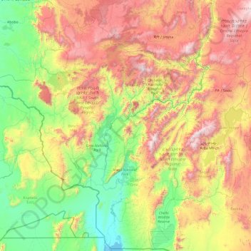
Name: Omo River topographic map, elevation, terrain.
Location: Omo River, Ethiopia (4.40785 35.89696 8.22268 37.61926)
Average elevation: 1,228 m
Minimum elevation: 361 m
Maximum elevation: 3,440 m
Make a donation
Gear up for your next adventure:
As an Amazon Associate, this site earns from qualifying purchases at no extra cost to you.
Other topographic maps
Click on a map to view its topography, its elevation and its terrain.
Adama
Ethiopia > Oromia Region > Adama
Adama (Oromo: Adaamaa or Hadaamaa), the city officially known as Adama formerly known as Nazret (ናዝሬት), is a city in central Oromia. Adama forms a Special Zone of Oromia and is surrounded by East shewa Zone. It is located at 8°32′N 39°16′E / 8.54°N 39.27°E / 8.54; 39.27 at an elevation…
Average elevation: 1,673 m
Ambo
Ethiopia > Oromia Region > Ambo Zuria
Ambo (Oromo: Amboo) is a town in west-central Ethiopia. Located in the West Shewa Zone of Oromia Region, west of Addis Ababa, this town has a latitude and longitude of 8°59′N 37°51′E / 8.983°N 37.850°E / 8.983; 37.850 and an elevation of 2,101 meters.
Average elevation: 2,384 m
Sawla
Ethiopia > South Ethiopia Regional State
Sawla (also known as Felege Neway) is a town in southern Ethiopia. Located in Gofa Zone of the Southern Nations, Nationalities and Peoples' Region, this town has a latitude and longitude of 6°18′N 36°53′E / 6.300°N 36.883°E / 6.300; 36.883 with an elevation of 1,395 metres (4,577 ft) above sea…
Average elevation: 1,485 m
Goba
Goba (Oromo: Gobbaa, Amharic: ጎባ) is a town and separate woreda located in the Bale Zone of the Oromia Region, Ethiopia approximately 446 km southeast of Addis Ababa, this city has a latitude and longitude of 7°0′N 39°59′E / 7.000°N 39.983°E / 7.000; 39.983 and an elevation of 2,743 meters above sea level.
Average elevation: 2,736 m
Make a donation
Gear up for your next adventure:
As an Amazon Associate, this site earns from qualifying purchases at no extra cost to you.
Dessie
Dessie (Amharic: ደሴ, romanized: Däse; also spelled Dese or Dessye) is a town in north-central Ethiopia. Located in the South Wollo Zone of the Amhara Region, it sits at a latitude and longitude of 11°8′N 39°38′E / 11.133°N 39.633°E / 11.133; 39.633, with an elevation between 2,470 and…
Average elevation: 2,450 m
Sokoru
The altitude of this woreda ranges from 1160 to 2940 meters above sea level; the highest points include Ali Shashema, Ali Derar and Kumbi. Perennial rivers include the Gilgel Gibe a tributary of the Gibe, and the Kawar; seasonal streams include the Melka Luku. A survey of the land in this woreda shows that…
Average elevation: 1,827 m
Make a donation
Gear up for your next adventure:
As an Amazon Associate, this site earns from qualifying purchases at no extra cost to you.
Make a donation
Gear up for your next adventure:
As an Amazon Associate, this site earns from qualifying purchases at no extra cost to you.
Make a donation
Gear up for your next adventure:
As an Amazon Associate, this site earns from qualifying purchases at no extra cost to you.
Tepi
Tepi (also transliterated Teppi and Tippi) is a town in southern Ethiopia. The vowels in the name are pronounced as in the English words tape and pea. Located in the Sheka Zone of the South West Ethiopia Region, this town has a latitude and longitude of 7°12′N 35°27′E / 7.200°N 35.450°E /…
Average elevation: 1,207 m
Mieso
Mieso (Oromo: Mi'eesso) is a town in eastern Ethiopia. Located in the West Hararghe Zone of the Oromia Region, it has a latitude and longitude of 9°14′N 40°45′E / 9.233°N 40.750°E / 9.233; 40.750 with an elevation of 1394 meters above sea level.
Average elevation: 1,369 m
Make a donation
Gear up for your next adventure:
As an Amazon Associate, this site earns from qualifying purchases at no extra cost to you.
Grand Ethiopian Renaissance Dam
Ethiopia > Benishangul-Gumuz Region
Supporting the main dam and reservoir will be a curved and 4.9 km (3 mi) long and 50 m (164 ft) high rock-fill saddle dam. The ground level of the saddle dam is at an elevation of about 600 m (2,000 ft) above sea level. The surface of the saddle dam has a bituminous finish, to keep the interior of the dam dry.…
Average elevation: 555 m
Bechena
Bichena (Amharic: ብቸና) is a town in northern Ethiopia. Located in the Misraq Gojjam Zone of the Amhara Region on the hillside overlooking the Abay River, it has a latitude and longitude of 10°27′N 38°12′E / 10.450°N 38.200°E / 10.450; 38.200 and an elevation of 2541 meters above sea…
Average elevation: 2,461 m
Make a donation
Gear up for your next adventure:
As an Amazon Associate, this site earns from qualifying purchases at no extra cost to you.
Holeta Genet
Ethiopia > Oromia Region > Walmara
Holeta (Oromo: Holataa) is a town in the special zone of Oromia Region, Ethiopia. It has a latitude and longitude of 9°3′N 38°30′E / 9.050°N 38.500°E / 9.050; 38.500 and an altitude of 2391 meters above sea level.
Average elevation: 2,391 m
Make a donation
Gear up for your next adventure:
As an Amazon Associate, this site earns from qualifying purchases at no extra cost to you.
Make a donation
Gear up for your next adventure:
As an Amazon Associate, this site earns from qualifying purchases at no extra cost to you.
Make a donation
Gear up for your next adventure:
As an Amazon Associate, this site earns from qualifying purchases at no extra cost to you.
Make a donation
Gear up for your next adventure:
As an Amazon Associate, this site earns from qualifying purchases at no extra cost to you.
Make a donation
Gear up for your next adventure:
As an Amazon Associate, this site earns from qualifying purchases at no extra cost to you.
Kamisee
Kemise (Oromo: Kamisee; Amharic: ከሚሴ) is a town and administrative seat of the Oromia Zone in the Amhara Region, Ethiopia. Kemise is 224 kilometres (139 mi) northeast of the Ethiopian capital, Addis Ababa and has a latitude and longitude of 10°43′N 39°52′E / 10.717°N 39.867°E / 10.717;…
Average elevation: 1,494 m
Make a donation
Gear up for your next adventure:
As an Amazon Associate, this site earns from qualifying purchases at no extra cost to you.
Make a donation
Gear up for your next adventure:
As an Amazon Associate, this site earns from qualifying purchases at no extra cost to you.
Make a donation
Gear up for your next adventure:
As an Amazon Associate, this site earns from qualifying purchases at no extra cost to you.
Mizan Teferi
Mizan Tefere (also called simply Mizan) is a town and the administrative center, of the Bench Sheko Zone in the South West Ethiopia Peoples' Region of Ethiopia. Located about 160 kilometers southwest of Jimma, Mizan Tefere has a latitude and longitude of 7°0′N 35°35′E / 7.000°N 35.583°E /…
Average elevation: 1,484 m
Yabēlo
Yabelo (Oromo: Yaabeelloo) is a town in southern Ethiopia. An alternative name for this town is Obda, which is also the name of a nearby mountain. Located northwest of Moyale in the Borena Zone of the Oromia, this town has a latitude and longitude of 4°53′N 38°5′E / 4.883°N 38.083°E / 4.883;…
Average elevation: 1,853 m
Make a donation
Gear up for your next adventure:
As an Amazon Associate, this site earns from qualifying purchases at no extra cost to you.
Make a donation
Gear up for your next adventure:
As an Amazon Associate, this site earns from qualifying purchases at no extra cost to you.
Make a donation
Gear up for your next adventure:
As an Amazon Associate, this site earns from qualifying purchases at no extra cost to you.
Make a donation
Gear up for your next adventure:
As an Amazon Associate, this site earns from qualifying purchases at no extra cost to you.
Make a donation
Gear up for your next adventure:
As an Amazon Associate, this site earns from qualifying purchases at no extra cost to you.
Make a donation
Gear up for your next adventure:
As an Amazon Associate, this site earns from qualifying purchases at no extra cost to you.
Make a donation
Gear up for your next adventure:
As an Amazon Associate, this site earns from qualifying purchases at no extra cost to you.
Sheraro
Sheraro (Tigrinya: ሸራሮ) is a town and separate woreda in Tigray, Ethiopia. It is located in the North Western Zone of the Tigray Region, at an elevation of 1246 meters above sea level. It is the administrative center of Tahtay Adiyabo. It is near the border with Eritrea.
Average elevation: 1,041 m
Bati
Bati (Oromo: Baati; Amharic: ባቲ) is a town in north-central Ethiopia. Located in the Oromia Zone of the Amhara Region, east of Dessie this town has a latitude and longitude of 11°11′N 40°1′E / 11.183°N 40.017°E / 11.183; 40.017 with an elevation of 1502 metres above sea level. It is the…
Average elevation: 1,450 m
Make a donation
Gear up for your next adventure:
As an Amazon Associate, this site earns from qualifying purchases at no extra cost to you.
Make a donation
Gear up for your next adventure:
As an Amazon Associate, this site earns from qualifying purchases at no extra cost to you.
Humera
Humera (Tigrinya: ሑመራ; Amharic: ሁመራ) is a town in the Kafta Humera woreda in the Tigray Region of Ethiopia. Located in the Western Zone the town has an elevation of 585 metres (1,919 ft) above sea level. The Tekezé river borders the town to the north. Humera is a very important regional…
Average elevation: 594 m
Make a donation
Gear up for your next adventure:
As an Amazon Associate, this site earns from qualifying purchases at no extra cost to you.
Germama/kesem
The Germama is not a navigable stream, and flows with a great volume during the rainy season. It rises west of Kese Koremash, flowing east to the Awash, its course delineating a few kilometers of the northern boundary of the Awash National Park. The Kessem River passes an altitude drop from more than 2000 m on…
Average elevation: 1,306 m
Make a donation
Gear up for your next adventure:
As an Amazon Associate, this site earns from qualifying purchases at no extra cost to you.